WhatsApp FAQs
×


PriceNote – Listed Price & Customisation Rules:
The listed trek price applies to our fixed departures for the specified itinerary. Trek fees including any add-ons for customized groups may vary based on your preferences, ensuring every adventure is tailored to your needs.

Group Booking Offer:
For groups of 8 or more booking together, the trek fee for 1 participant will be waived as a token to encourage shared adventures.

Scholarship for Kids:
Children under 15 years receive a 30% discount on the trek price, making it easier for families to explore the Himalayas together.

×


Transport Price Note:
The transport price mentioned is only an current indicative estimate per person, assuming a Non-AC vehicle like Bolero shared by at least 4 participants.
Fewer participants → cost rises;
More participants → cost decreases.

Transport Selection During Booking:
Selecting transport during booking informs us of your preference. No payment is collected at booking.

Final Cost & Payment:
Final transport cost will be communicated before departure and to be paid directly to the cab driver.

×

Itinerary Note:
This itinerary represents the most updated plan, but minor adjustments may occur due to operational needs or mountain conditions.

Pindari & Kafni Glacier Trek

A Classic Kumaon Himalayan Adventure

Gallery

Trek Overview

  • Trek Duration: 7 Nights / 7 Days
  • Trek Grade: Moderate
  • 🏔️ Max Altitude: Approx. 3,850 m
  • Trek Distance: Approx. 70 Km
  • 🌤️ Best Time: April–June & September-October
  • 🗺️ Region: Kumaon Himalayas, Uttarakhand
  • 📍 Start Point: Khati
  • 🏁 End Point: Khati
  • 🧥 Cloakroom facility: Available

Price starting from ?

INR 17,400 * Khati to Khati

*Price inclusive of all applicable taxes (GST included).

Small group sizes • High guide-to-trekker ratio • No hidden costs

Addons (Optional)

  • Transportation – INR 5,000 (* Kathgodam to Kathgodam (shared vehicle basis)) ?
  • Offloading-Bags – INR 4,500 (* Maximum weight 9kg / bag)

Need help or want a custom plan?

Walking The Trail

The Pindari–Kafni Glacier Trek unfolds as a deeper passage into Kumaon’s glacial heart, where two distinct valleys—shaped by ice, rivers, and time—gradually reveal their character. Beginning from the last inhabited village of Khati, the trail does not rush into the mountains; it eases you in. Forests of oak, pine, and rhododendron close in around the path, the Pindar River stays constant beside you, and the valley begins to stretch ahead—not dramatically, but with quiet intent.
As the journey progresses toward Dwali and beyond, the terrain begins to shift in layers. The dense forest corridors break into open sections, landslide zones expose the raw structure of the valley, and the river cuts deeper into the landscape. This is not just a trail—it is a corridor once used for movement, trade, and survival, where every bend carries the imprint of natural forces that continue to reshape it.
Above Phurkia, the transformation is unmistakable. Vegetation thins, the air sharpens, and the valley opens into a high-altitude glacial basin. The approach to Pindari Glacier is defined by moraine fields, snow bridges, and fractured terrain—subtle indicators of a living glacier system constantly in motion. Peaks like Nanda Khat (6,611 m) and Changuch (6,322 m) rise with clarity, while the glacier itself reveals not as a single moment, but as a gradual realization of scale and silence.
Just as the Pindar Valley begins to settle into familiarity, the route shifts again—this time into the quieter and more isolated Kafni Valley. Narrower, less travelled, and more contained, Kafni offers a different kind of experience. The trail feels closer to the terrain, the forests denser, and the glacier basin more intimate. Dominated by the massive presence of Nanda Kot (6,861 m), this valley does not overwhelm—it absorbs, drawing you into a quieter understanding of the mountains.
Together, these two valleys create a rare continuity—one broad and expressive, the other inward and restrained. Over the course of the journey, the Himalayas are not presented as a single spectacle, but as a system—of rivers, glaciers, forests, and ridgelines, all connected and constantly evolving.
By the time the trail returns to Khati, the experience no longer feels like a sequence of destinations. It becomes a progression—of terrain, altitude, and perspective—where the mountains are not just seen, but gradually understood in parts.
What makes the Pindari–Kafni Glacier Trek stand apart is not just its accessibility or its visual range, but the way it allows time for immersion. Over multiple days, it moves through ecosystems, introduces glacial landscapes, and balances exposure with depth—making it both a complete introduction to Himalayan trekking and a journey that continues to stay with you long after it ends.
Read More

Highlights

✅ A rare dual-valley experience covering both the expansive Pindar Valley and the quieter, more isolated Kafni Valley

✅ Close approach to the Pindari Glacier snout, revealing active moraine fields, ice formations, and the raw dynamics of a living glacier

✅ Exploration of the lesser-trekked Kafni Glacier basin, set beneath the massive presence of Nanda Kot (6,861 m)

✅ Layered Himalayan landscapes transitioning from dense oak, pine, and rhododendron forests to alpine meadows and high-altitude glacial terrain

✅ Continuous river companionship along the Pindar and Kafni rivers, shaping the valley’s depth, soundscape, and movement

✅ Historic trail through the Johar region, once part of ancient Indo-Tibetan trade routes used by local communities and traders

✅ Grand Himalayan views featuring peaks like Nanda Khat (6,611 m), Changuch (6,322 m), Nanda Kot (6,861 m), and Maiktoli (6,803 m)

✅ Classic Kumaoni mountain villages like Khati and Dwali, offering a glimpse into traditional Himalayan life and architecture

✅ A complete glacial ecosystem experience—moraine walks, snow bridges, alpine basins, and shifting high-altitude weather patterns

Itinerary

?
• Arrival & Reporting
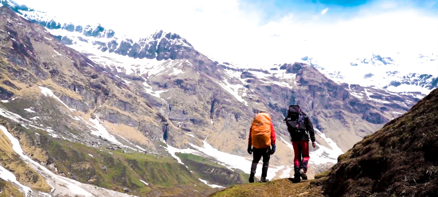
• Today marks your arrival into the Kumaon Himalayas, as you make your way toward Khati—the last inhabited village of the Pindar Valley and the starting point of your journey ahead. Most travellers approach via Haldwani/Kathgodam, following a long but incredibly scenic mountain drive through Bheemtal, Almora, Bageshwar, and Kapkot.
• As the road leaves behind the busier hill towns, the landscape begins to shift—valleys deepen, forests grow denser, and the mountains start to feel more intimate and less travelled. Beyond Kapkot, the route narrows and winds through remote sections, eventually leading toward Loharkhet and further into the interior of the valley.
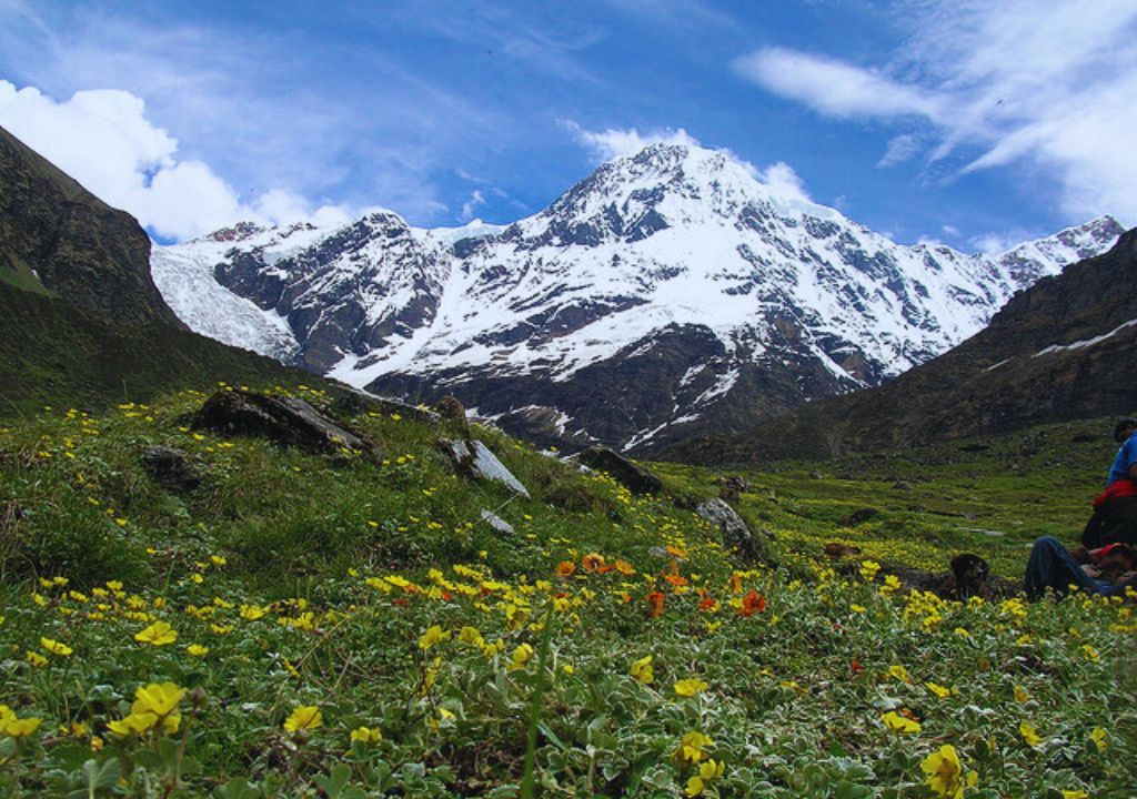
• Khati sits quietly amidst this setting—wooden homes, terraced fields, and a pace of life that feels unchanged over time. With limited connectivity and largely solar-powered electricity, the village naturally disconnects you from the outside world even before the trek begins.
• Trekkers are expected to reach Khati by evening and report at the designated meeting point. The rest of the day is kept flexible to allow for travel variations. Once everyone has arrived, you settle into camp/homestay, meet your trek team, and prepare for the journey into the Pindar Valley starting the next morning.
• Trek: 13 km | Duration: 6–7 hrs
• After a hearty breakfast, begin your long walk toward Dwali. The Pindar River accompanies you throughout the day, filling the trail with the sound of rushing water. The route includes wooden bridges, cascading waterfalls, and several landslide-prone sections created by the 2013 disaster—so caution and following the trek leader’s instructions are essential.
• The first 20 minutes involve a steep ascent offering a bird’s-eye view of Khati. The gradient eases soon after, leading you to a stream—your first water point. Passing KMVN lodges, you reach a wooden bridge that crosses the first landslide zone before the trail narrows and descends into dense forest with the Pindar River gushing on your left.
• Multiple landslide zones follow, requiring detours down to the riverbank. You will navigate boulders, moraines, temporary trails, and steep reconnecting climbs back to the original ridge. Each section demands careful footwork, especially the longer detour where you cross huge boulders and four scissor bends before climbing back up through dense vegetation.
• After reconnecting with the main trail, an uphill stretch leads you to the sixth and final landslide zone. The descent to the river is loose and unstable, followed by a moraine walk to the final river crossing. Once across, you reach Dwali—an area still showing scars of the 2013 calamity.
• By evening, settle into the Dwali campsite with panoramic valley views. Drinking water is available nearby, and after dinner, rest in your tents for the night.
• Trek: 5 km | Duration: 3 hrs
• Today’s trek is comparatively easier and shorter. After a warm breakfast, begin your ascent through beautiful Oak and Rhododendron forests. Clear weather offers spectacular views of Mt. Nanda Devi and Nanda Khat, while the trail gradually winds deeper into the Pindar Valley with forested switchbacks and scenic meadows perfect for photography.
• Look out for Himalayan Ibex grazing in the pastures across the river. As you continue along the verdant grasslands, you will cross two glacial streams—often frozen into hard layers of snow. The trail also includes a few landslide-prone patches and narrow spiderwall sections, where your trek leader will guide you through safely.
• After navigating these tricky segments, you’ll cross the final snow bridges and follow the left bank of the river toward Phurkia. Landmarks like the KMVN and PWD huts mark your arrival. The Phurkia campsite welcomes you with stunning views of the towering Nanda Khat peak. After pitching your tents, enjoy a hot meal and rest for the night.
• Trek: ~17 km | Duration: 7–8 hrs
• Today is the defining day of the Pindari Valley. Starting early from Phurkia, the trail moves into a stark, glacial landscape where vegetation fades and the terrain becomes raw and exposed. Snow bridges, moraine fields, and broken ridgelines guide your way toward the upper basin.
• As you approach Zero Point, the valley opens into a wide glacial amphitheatre. The Pindari Glacier stretches ahead—layered with ice, rock, and time—while peaks like Nanda Khat and Changuch rise sharply around you, shaping both the skyline and the weather patterns of the region.
• The experience here is less about reaching a point and more about understanding the scale of the Himalayas—the slow movement of ice, the silence of high altitude, and the ruggedness of terrain that constantly reshapes itself.
• After spending time at the glacier, the descent begins immediately all the way down to Dwali. The return journey is long but gradual, with the harsh glacier zone slowly transitioning into greener valley sections. By the time you reach Dwali, the return of trees and river sounds feels grounding after the starkness above.
• Trek: ~5 km | Duration: 2–3 hrs
• After the long glacier day, today is intentionally shorter. The trail descends gently along the Pindar River, moving back into dense forests of Oak and Rhododendron.
• The valley here feels alive again—bird calls, flowing water, and thick vegetation replace the silence of higher altitudes. This stretch also allows you to observe how quickly Himalayan ecosystems change with altitude.
• Reaching Khati or Bayali, you return to the last inhabited section of the valley. Wooden homes, terraced fields, and signs of daily life create a contrast to the untouched upper reaches you’ve just experienced.
• The evening is calm and restorative, giving your body time to recover before heading into the quieter Kafni Valley the next day.
• Trek: ~14–16 km | Duration: 7–8 hrs
• Today you leave the main Pindari route and enter the lesser-explored Kafni Valley—a quieter, narrower, and more isolated extension of the region.
• The trail initially follows the Pindar River before branching into the Kafni valley, where the landscape immediately feels different—denser forests, fewer trekkers, and a more intimate connection with the terrain.
• As you gain altitude, the valley tightens before opening into alpine sections leading toward the Kafni Glacier. Unlike Pindari, this glacier sits in a more enclosed basin, with the massive presence of Nanda Kot(6,861 m) dominating the skyline.
• The experience here is quieter and more introspective—less dramatic in scale, but deeper in isolation. You spend time exploring the glacier viewpoint before returning along the same trail to Khati/Bayali.
• This day adds a second dimension to the trek—showing how two neighboring valleys can feel completely different in character.
• Trek: ~18 km | Duration: 7–8 hrs
• The final trekking day retraces your path through the Pindar Valley, descending steadily along the river and through familiar forest sections. The trail, once demanding, now feels more intuitive—every bridge, ridge, and bend carrying a sense of recognition.
• Moving alongside the Pindar River, the valley slowly shifts back into its lived-in form—dense forests, occasional clearings, and the quiet presence of villages returning into view.
• By the time you reach Khati, the journey comes full circle. What began as an entry into the mountains now settles into a quiet sense of completion. The evening is unhurried—shared over a warm meal, stories from the trail, and the lingering presence of the valley that shaped the past few days.

• End of Trek: The trek officially concludes at Khati with dinner and an overnight stay.
• Departure: The following morning is departure. Trekkers are expected to check out by 10:00 AM and continue their onward journey. Drop transport to Kathgodam is an additional service on request.

Packing list

For a comprehensive packing list, download the PDF below: Download Packing List

Did you know?

The Pindari Glacier was among the earliest glaciers in the Kumaon Himalaya to be surveyed in detail by British explorers in the 19th century, making this valley one of the birthplaces of Himalayan trekking in India.
Unlike Pindari, the Kafni Valley has remained relatively untouched—not because it is inaccessible, but because it was never part of major trade or expedition routes, preserving its quieter and more isolated character.
The Pindar River originates directly from the snout of the Pindari Glacier and eventually feeds into the Alaknanda River, making it part of the larger Ganga river system that sustains millions downstream.
Kafni Glacier sits in a more enclosed basin compared to Pindari, which is why its approach feels more intimate—less expansive, but more immersive and silent.
The villages in this region, especially Khati, were once part of seasonal trade networks connecting to the Johar Valley, where traders would move goods toward Tibet before border closures ended these routes.
Early expedition records show that the Pindari Glacier has been retreating steadily for over a century, with visible shifts in the snout position and moraine spread—something trekkers can still observe today.
Peaks like Nanda Kot (6,861 m) and Maiktoli (6,803 m) play a direct role in shaping the glaciers here—their snow accumulation feeds the ice systems that define both Pindari and Kafni valleys.
The transition from dense forest to alpine terrain on this trek happens over a relatively short distance, making it one of the best routes to observe how Himalayan ecosystems change with altitude.
Kafni Valley is often skipped by trekkers due to time constraints, which is why those who include it experience a side of Kumaon that feels far less travelled despite being so close to a popular route.
Many sections of the trail you walk today were originally formed not for trekking, but by shepherds and local movement—meaning the path follows the natural logic of the terrain rather than modern design.
The silence near both glaciers is not just the absence of sound—it’s the absence of human presence, something that becomes more noticeable in Kafni than in the busier Pindari valley.
During early summer, snow bridges form naturally over glacial streams, but they weaken rapidly as temperatures rise—this is why timing and guidance are critical on glacier approaches.
The contrasting character of Pindari (broad, open, and historically explored) and Kafni (narrow, quiet, and less disturbed) offers a rare opportunity to experience two different Himalayan moods within the same trek.
For many trekkers, the most lasting memory isn’t the glacier itself, but the gradual transition between ecosystems—where forests, rivers, and ice all exist within a single continuous journey.

Route Map

How to reach

✈️ Air: Nearest airport: Pantnagar Airport – 240 km from Bageshwar. Taxis available to Kharkiya/Khati.

🚆 Train: Nearest major railway station: Kathgodam. From there, take a shared cab or private taxi to Bageshwar, then onwards to Kharkiya/Khati.

🛣️ Road: From Delhi: Overnight bus to Haldwani/Kathgodam, then taxi to Bageshwar → Kharkiya → Khati. Roads remain open most of the year.

🗺️ Travel Tip: Arrive in Khati one day early to acclimatise and enjoy the village before starting the trek.

TrekFAQs

  • This trek is suitable for beginners with good fitness as well as experienced trekkers. The trail includes long walking days, multiple stream crossings, and several landslide-detour sections, so basic endurance and balance are essential.
  • The Pindari Glacier Trek spans 7 days, with daily trekking distances ranging from 5 km to 18 km depending on the terrain. Summit day involves walking on snow patches, moraine, and glacier sections, so pacing and hydration are important.
  • The trek is rated as moderate. No prior high-altitude experience is required, but you should be comfortable walking 6–7 hours a day. The landslide zones between Khati, Dwali, and Phurkia require caution and attention to your trek leader’s instructions.
  • The best season is spring to early summer (April–June) and post-monsoon (September–November). Snow on the trail is highest in April–May, while October offers the clearest mountain views, including Nanda Khat and Nanda Devi East.
  • The highest points are the Pindari Glacier Zero Point at around 3,700 m. and Kafni Glacier Point at around 3,850m. Mild symptoms like breathlessness or headaches can occur, so hydration and steady pacing are key to avoiding altitude-related discomfort.
  • Accommodation is in tents throughout the trek, with campsites at Khati, Dwali, Bayali, and Phurkia. Meals include hot vegetarian dishes, dal, rice, vegetables, roti, Maggi, soup, tea, and snacks. Campsites have drinking water sources nearby.
  • Carry warm layered clothing, waterproof jackets, trekking shoes, gloves, caps, sunglasses, and a sturdy backpack. On summit day, microspikes and gaiters may be used depending on snow conditions. Trekking poles are very helpful.
  • Travel insurance is strongly recommended, covering high-altitude trekking, medical emergencies, evacuation, and weather-related delays. It is not included by default.
  • Certified trek leaders guide the group, especially through landslide-prone detours, spider-wall sections, and snow patches. The team carries first-aid kits, and communication is maintained with Khati and Dwali. Campsites are checked for safety, and water sources are verified.
  • Minor issues like fatigue, dehydration, and slips on loose gravel can happen. In case of serious medical issues, evacuation is arranged back towards Khati or Loharkhet, the nearest road-head. Always report discomfort early.
  • Only BSNL works intermittently in Khati. Beyond Khati (Dwali, Phurkia, and Zero Point), the trail is completely off-grid with no mobile connectivity.
  • Yes, trekkers often spot Himalayan Ibex near streams and meadows, along with birds like Monal and Himalayan Griffon. The forests around Khati and Dwali are also rich in flora like rhododendron and oak.
  • Yes, there are multiple water points, including streams near Khati, Dwali, and on the way to Phurkia. Many sections involve stream crossings or snow bridges, making it easy to refill bottles after purification.
  • Khati village is known for its warm hospitality and mythology linked to the Pandavas. Dress modestly, respect local traditions, and seek permission before photographing villagers or homes.
  • Yes, you can offload your backpack by hiring a porter or mule from Khati. Prior booking is recommended, especially during the peak season.

Similar Treks

View of Nanda Devi East Base Camp Trek trek moderate, difficult

Nanda Devi East Base Camp Trek

8 Nights / 8 Days
uttarakhand-kumaon
View of Sunderdhunga Valley Trek trek difficult

Sunderdhunga Valley Trek

7 Nights / 7 Days
uttarakhand-kumaon
View of Miyar Valley Trek trek moderate

Miyar Valley Trek

7 Nights / 7 Days
himachal pradesh
View of Kalihani Pass Trek trek moderate, difficult

Kalihani Pass Trek

7 Nights / 8 Days
himachal pradesh
View of Buran Ghati Trek trek moderate, difficult

Buran Ghati Trek

6 Nights / 7 Days
himachal pradesh
View of Gaumukh Tapovan Trek trek moderate, difficult

Gaumukh Tapovan Trek

6 Nights / 6 Days
uttarakhand-garhwal
View of Kedartal Trek trek moderate, difficult

Kedartal Trek

6 Nights / 6 Days
uttarakhand-garhwal
View of Satopanth Lake Trek trek moderate

Satopanth Lake Trek

5 Nights / 5 Days
uttarakhand-garhwal

How Our Treks Are More Than Just a Trek

Every journey with us is carefully crafted for a deeply personal mountain experience.

Not Just a Trek — A Journey That Stays With You

Every trail we walk is a carefully chosen path into the heart of the Himalayas — not just to witness their grandeur, but to feel them under your skin and soul. Our treks are designed not as bucket list checkmarks, but as life-affirming journeys. At Planethimalayas, we believe a mountain journey is deeply personal — and that belief runs through everything we do.

Individual Care, Every Step of the Way

We keep our groups small and intimate so we can focus on you — your pace, your concerns, your joy. From pre-trek guidance to trail-side support, our leaders walk with intention, offering safety and attention without intrusion. It’s this deep care that turns strangers into friends and walks into memories.

Built on Genuine Love for the Himalayas

We don’t just operate in the Himalayas — we live and breathe them. From respecting mountain communities to following Leave No Trace ethics, our treks are shaped by humility and care. With Planethimalayas, your trek becomes a way of giving back to the mountains that give us so much.

Why Choose Us

Experience the difference of trekking with genuine mountain experts who truly care.

Trek Leader & Guide

Led by certified mountaineers with wilderness first aid training, ensuring your safety and confidence at every step.

Cook & Support Staff

Our mountain crew comprises local experts who bring unmatched experience, warmth, and deep knowledge of the region.

Small Group Size

We cap our group departures at just 8 trekkers — ensuring individual attention, deeper connections, and better trail discipline.

Safety Standards

From personal well-being to technical preparedness, we maintain the highest safety standards — using certified high-altitude gear and comprehensive safety protocols to ensure a secure and reliable Himalayan experience.

24×7 Online Support

We're always available — before, during, or after your trek. Reach out anytime, and you'll always hear back from a real human.

We Care for the Mountains

We strictly follow Leave No Trace ethics. Limited group sizes and mindful practices help protect the fragile Himalayan ecosystem.