Trekking in the Himalayas is a true adventure experience — a journey into high-altitude wilderness where nature exists in its most raw and powerful form. Every trek comes with physical challenges, unpredictable weather, and varying terrain. Choosing the right trek grade is essential not just for a great experience, but also for safety and proper acclimatization.
To help you make the right choice, treks are categorized into three levels based on altitude, terrain, duration, and overall difficulty:
Easy (Beginner-Friendly Treks):
Ideal for first-time trekkers or those looking for an easy trek in the Himalayas. These treks usually last up to a week, with shorter hiking days, gradual altitude gain, and a maximum altitude of around 14,000 ft. The terrain remains well-defined, often within or near the tree line, with civilization relatively accessible. Weather conditions are more predictable, making these treks safer and easier to manage, with quicker rescue access if required.
Moderate Treks:
Designed for trekkers with some prior experience or good fitness levels. These treks may extend beyond a week and include a mix of short and long trekking days, with altitudes reaching up to 16,000 ft. You move above the tree line into more rugged landscapes — including alpine meadows, moraines, and high-altitude terrain. Weather becomes more unpredictable, and conditions can change suddenly. While still manageable, these treks require better preparation, endurance, and mental strength.
Difficult (Expedition-Level Treks):
These are high-altitude expeditions meant for experienced trekkers. Routes often exceed 17,000 ft and pass through glaciers, snowfields, steep ascents, river crossings, and technical terrain. Treks can last up to two weeks, taking you far from civilization into extreme Himalayan conditions. Weather can shift rapidly, and sections may require technical equipment like ropes or ice axes. Rescue in such regions is complex, making experience, self-sufficiency, and strong mental resilience absolutely essential.
Understanding these categories helps you choose a trek that matches your fitness, experience, and expectations — ensuring a safe, enjoyable, and truly memorable Himalayan adventure.
×
PriceNote – Listed Price & Customisation Rules:
The listed trek price applies to our fixed departures for the specified itinerary. Trek fees including any add-ons for customized groups may vary based on your preferences, ensuring every adventure is tailored to your needs.
Group Booking Offer:
For groups of 8 or more booking together, the trek fee for 1 participant will be waived as a token to encourage shared adventures.
Scholarship for Kids:
Children under 15 years receive a 30% discount on the trek price, making it easier for families to explore the Himalayas together.
×
Transport Price Note:
The transport price mentioned is only an current indicative estimate per person, assuming a Non-AC vehicle like Bolero shared by at least 4 participants. Fewer participants → cost rises; More participants → cost decreases.
Transport Selection During Booking:
Selecting transport during booking informs us of your preference. No payment is collected at booking.
Final Cost & Payment:
Final transport cost will be communicated before departure and to be paid directly to the cab driver.
×
Itinerary Note:
This itinerary represents the most updated plan, but minor adjustments may occur due to operational needs or mountain conditions.
×
Terms & Conditions
Trekking is an adventurous activity that inherently involves a variety of risks and uncertainties. By choosing to trek with Planethimalayas, I acknowledge and accept the following potential hazards:
Natural Threats:
Unpredictable Weather: I understand there is always a possibility of facing sudden rain, cloudbursts, flash floods, or Glacial Lake Outburst Floods (GLOFs), either during the trek or at the campsite. Harsh weather conditions such as hailstorms, thunderstorms, lightning, high-altitude winds, and abrupt temperature drops can not only affect comfort but may also lead to the cancellation of the trek without prior notice.
Wildlife Encounters: Trekking trails may intersect with habitats of wild animals including bears, snakes, and a range of insects or arthropods. These encounters pose serious risks.
Flora Exposure: Some plant species in the trekking regions may be toxic or harmful upon contact or ingestion. I understand that interacting with such vegetation could result in serious consequences.
Natural Calamities: Mountainous terrains are prone to landslides, avalanches, earthquakes, and whiteouts — all of which could significantly endanger life and disrupt the trek.
Altitude and Injury Risks:
High-altitude conditions can lead to Acute Mountain Sickness (AMS), High Altitude Pulmonary Edema (HAPE), or High Altitude Cerebral Edema (HACE).
I understand that trekking surfaces are uneven and potentially slippery. This increases the chance of falls, slips, or injuries — including accidental drowning.
Misuse or malfunctioning of trekking gear (e.g., trekking poles, safety equipment) may also result in accidents.
Accidents during the trek could cause emotional or physical trauma, temporary or permanent disabilities, or even paralysis.
Injuries caused by fellow trekkers or locals are also possible.
I acknowledge that sun exposure, extreme cold, or environmental factors may cause health issues such as sunburn, frostbite, hypothermia, dehydration, heatstroke, chilblains, or hypoxia.
Medical Emergencies:
Trekking routes often lack access to nearby hospitals or clinics. I understand that medical attention may be delayed or unavailable.
I am aware that evacuation due to an emergency may be logistically difficult and time-consuming.
Additional Concerns:
Civil or Political Disturbance: Unrest due to protests, strikes, conflicts, or terrorism may impact trek safety.
Equipment Failures: I accept that gear failure could lead to difficulties or injuries.
Transportation Disruptions: Travel to or from the basecamp may be delayed or disrupted due to vehicle failure, cancellations, or roadblocks.
Disease Exposure: Trekking in unfamiliar regions may expose me to infectious diseases or health risks.
By agreeing to this document, I confirm:
I am fully aware of the above-mentioned risks.
I am voluntarily participating in the trek.
I agree to follow all safety protocols and guidance provided by Planethimalayas staff.
I will take full responsibility for any gear or equipment used during the trek.
I acknowledge that while Planethimalayas’ staff are trained and experienced, they are human and cannot foresee or prevent every risk.
My safety and well-being ultimately remain my responsibility.
I take full ownership of my physical readiness for the trek, based on the eligibility and fitness standards set by Planethimalayas.
Health Statement:
I certify that I am physically and mentally fit.
I have no known medical conditions that could restrict me from undertaking the trek.
No medical professional has advised me against participating in this activity.
Legal Liability:
I confirm that I am solely accountable for my safety throughout the trek.
I voluntarily assume all known and unknown risks involved.
Planethimalayas is not liable for any injuries, illnesses, or losses sustained during or after the trek.
I understand that Planethimalayas will not cover any medical costs I may incur.
Should my actions cause harm or inconvenience to another person or damage to property — whether intentionally or by accident — I agree to compensate Planethimalayas for any resulting expenses. This includes costs related to repairs, medical treatments, or legal actions.
I am aware that high-altitude trekking may cause symptoms related to oxygen deprivation and altitude sickness. If the trek leader believes it is unsafe for me to continue, I accept their decision to descend me to a safer altitude.
I understand that health checks (oxygen level, pulse, blood pressure) will be conducted regularly at various camps. Based on these assessments, Planethimalayas reserves the right to disallow me from proceeding further if my health metrics fall below acceptable standards. These standards are available with trek leaders.
I am aware that the terrain will involve challenging and unpredictable conditions including steep slopes, snow-covered paths, and rocky trails.
If the trek leader concludes that I am physically unable to complete the trek without constant support, I understand that I may be turned around.
Alcohol, tobacco, and any recreational drugs are strictly banned throughout the trek. Consumption of such substances may result in immediate removal from the trek and basecamp.
I have read and fully understood all the terms stated in this agreement. I consent to the conditions knowing the legal impact it may have. Even if any clause here is declared unenforceable, the remainder shall remain valid.
I acknowledge that the trek cost was calculated assuming my full consent to these terms. Without this agreement, Planethimalayas would not be able to offer the trek services.
I agree that my electronic or digital acceptance of this agreement shall hold the same validity as a signed physical document.
It is solely my duty to carry all necessary documents related to this trek (passport, ID, permits, visa, etc.). Planethimalayas will not be held responsible if I fail to present these documents when required.
Planethimalayas also disclaims liability in case of loss, theft, or damage to any personal identification or travel documents.
I voluntarily consent to provide my Aadhaar number for use by Planethimalayas in matters related strictly to identity verification, trek permit processing, and administrative formalities. This data will be used solely for these purposes in accordance with Indian law. I understand I may withdraw this consent prior to its usage by submitting written notice.
I agree to abide by the cancellation policy of Planethimalayas as outlined in the official document.
🩺 Basic Medical Support – On-trek first aid and support for minor medical issues
👥 Support Staff – Team includes experienced trek leaders, local guides, cooks, and helpers
🎯 Qualified Leadership – Professional trek leader overseeing safety and coordination
❌ Exclusions
🚑 Insurance – Travel or medical insurance is not included
🚨 Emergency Costs – Expenses for evacuation, rescue, or medical treatment are not covered
🎒 Backpack Offloading – Available as an optional add-on at an extra charge
🚗 Travel to/from Base Camp – Transport to the trek base or return is not part of the package unless opted separately
🛍️ Personal Purchases – Items bought on the way (snacks, gifts, souvenirs, etc.) are not included
👕 Personal Trek Gear – Jackets, shoes, walking sticks, or toiletries are not part of the package (can be rented separately)
❗ Anything Not Listed Above – If it’s not mentioned under inclusions, it is not covered by Planethimalayas
×
Cancellation & Refunds
At Planethimalayas, we strive to make your trekking experience smooth and transparent. Please read our cancellation policies carefully:
1. Trek Cancellation by Participant
Within 30 days prior to departure: Full refund of trek fees.
Between 30 to 15 days prior to departure: 20% of trek fee will be retained; the remaining amount will be refunded.
Less than 15 days prior to departure or no-show: No refund.
2. Trek Cancellation by Planethimalayas
In the unlikely event that Planethimalayas cancels a trek due to weather, natural disasters, political unrest, or any unforeseen circumstance, we will provide you with the option to join another trek of the same value or issue a full refund.
3. Refund Policy
Refund Method: All approved refunds are issued as vouchers tied to the specific participant's account and can be used for future treks. Direct cash or online refunds are not provided.
4. Rescheduling & Changing Treks
Rescheduling a trek to a different date is free of charge.
Changing to a different trek must be requested at least 30 days prior to departure.
If the selected trek is of higher price, the extra amount must be paid.
If the selected trek is of lower price, the remaining amount will be refunded within 10 days after trek completion.
Requests made within 15 days of departure are handled on a case-by-case basis.
5. Transport & Offloading Bag Add-on Cancellation
Cancellation more than 72 hours prior to departure: Full refund.
Cancellation within 72 hours or post that period: No refund possible.
Important Note: In case of emergencies or rescue operations, any transportation used during such processes will not be considered part of the Transport add-on, and trekkers must bear all costs incurred. It is strongly recommended to purchase proper trek insurance to claim such costs as per your insurance policy.
6. Cancellation Requests
All cancellations must be processed through email only. No other form of communication will be considered official. Our official email address:
info@planethimalayas.com
Mayali Pass Trek
An Ordeal of Grit and Endurance Across the Sacred Himalayan Lakes
Offloading Bags – INR 7,200 (* Maximum weight 9kg/bag)
Need a different date?
We can arrange a custom departure if 3+ trekkers align.
Walking The Trail
The Mayali Pass Trek begins deep in the Bhilangana valley, far beyond where most mountain roads end. The drive to Gangi itself sets the tone — The drive from the plains winds upward along the Bhilangana valley, passing the vast expanse of Tehri Dam, where the scale of human engineering slowly gives way to the dominance of the Himalayas. Beyond this, the road narrows, the valleys deepen, and settlements grow quieter until you arrive at Gangi — a remote village where the road ends and the mountains take over.
Life here moves with a quiet rhythm. Stone houses, terraced fields, and the constant presence of the Bhilangana river define the landscape. The trail begins gently, but the wilderness ahead is unmistakable. As you move beyond Gangi and Guttu, the path enters dense forests — raw, untouched, and known to be home to Himalayan wildlife. Campsites like Kharsoli and Tambakund emerge as small clearings in this vastness, surrounded by towering trees and the distant sound of flowing water. The trail here is far from straightforward, often broken by stream crossings, loose sections, and landslide-prone stretches that demand attention at every step.
As the trek progresses, the route toward Chowki introduces one of its first true tests — crossing the Bhilangana river. At times, a makeshift shepherd bridge offers passage, though its reliability is never certain. When conditions do not permit, the trail pushes further ahead to safer crossing points, adding both distance and challenge. Upon reaching Chowki, the landscape opens dramatically. The Bhilangana valley stretches out in sweeping layers, framed by towering ridgelines and distant peaks, offering a rare moment of perspective before the intensity ahead.
Beyond Chowki, the character of the trek shifts completely. The climb toward Masar Tal is steep and relentless, cutting through rugged terrain where each step demands effort. Masar Tal itself appears like a hidden world — a high-altitude glacial lake set against a stark, silent backdrop. From here, the ascent to Masar Top grows sharper, leading into an exposed alpine environment where the trail fades into moraine and snowfields. Crossing near Paiyan Tal, the route traverses vast glacial expanses, where direction is guided more by experience than by any visible path.
This entire stretch — from Masar Tal to Mayali Pass and further down to Vasuki Tal — forms the core of the trek. It is long, demanding, and constantly changing. The terrain never stays the same: snow, ice, loose rock, and hidden crevasses shape the journey. The intensity here is dictated entirely by conditions — weather, snow cover, and timing — often requiring patience, adaptability, and sometimes even an additional buffer day.
The final approach to Mayali Pass is a steady, exhausting climb over glacial terrain. At the top, the world opens in every direction — a vast, silent expanse of peaks and ridgelines stretching across the Garhwal Himalayas. The descent, however, is immediate and unforgiving, dropping sharply over snow and moraine toward the Mandakini valley. As you lose altitude, the stark landscape gradually softens, leading to the sacred waters of Vasuki Tal, where the peaks of the Kedarnath range begin to dominate the horizon.
From Vasuki Top, the first clear views into the Kedarnath valley emerge — a striking contrast after days spent in isolation. The sight of Kedarnath, along with the distant movement of pilgrims, feels almost surreal. After enduring the silence and intensity of the high mountains, the return to human presence carries a different kind of weight — one of reflection, completion, and quiet gratitude.
The final descent follows the well-defined pilgrim trail from Kedarnath to Gaurikund. What was once a remote and uncertain journey gradually merges into a path walked by thousands, bringing the expedition to a close.
With Planethimalayas, the Mayali Pass Trek is approached as a true Himalayan expedition — one that demands resilience, awareness, and respect for the mountains. It is not just about crossing a pass, but about experiencing the full depth of the Himalayas in their most raw and unpredictable form — a journey that stays with you long after it ends.
Read More
Highlights
✅ A remote high-altitude crossover connecting the Bhilangana valley to the Mandakini (Kedarnath) valley
✅ Journey through dense, bear-inhabited Himalayan forests with raw and untouched wilderness
✅ Isolated campsites like Kharsoli, Tambakund, and the vast open expanse of Chowki
✅ Frequent river crossings, landslide zones, and constantly shifting trail conditions
✅ Sacred high-altitude lakes including Masar Tal, Paiyan Tal, and Vasuki Tal
✅ Steep and demanding ascent to Mayali Pass (~5,300 m) across moraine, snow, and glacial terrain
✅ Unpredictable weather and long, committing stretches requiring endurance and adaptability
✅ Panoramic views of Gangotri region peaks like Thalaysagar, Jogin, and Meru from the Bhilangana valley
✅ Stunning perspectives of Kedarnath region peaks like Nanda Devi, Kedarnath, Chaukhamba, Kedar Dome, and Karchakund on descent into the Mandakini valley
✅ A rare transition from deep wilderness to the sacred landscape of Kedarnath
✅ Trek concludes at the iconic Kedarnath Temple after days of remote high-altitude isolation
Itinerary
?
The journey begins early from Rishikesh, gradually leaving behind the crowded plains as the road climbs steadily into the Garhwal Himalayas. The drive follows the Bhagirathi valley for a while before branching toward Tehri, where the vast expanse of the Tehri Dam reservoir dominates the landscape. The scale here feels immense — still waters stretching deep into the mountains, surrounded by steep ridgelines.
Beyond Tehri, the road narrows and the terrain begins to feel more rugged and remote. The route winds through small mountain settlements and dense forest sections, with the valley growing quieter with every passing kilometer. As you move deeper, the presence of the Bhilangana valley becomes more pronounced — narrower, steeper, and far less inhabited.
A key halt along the way is Ghuttu (5177 ft), a well-known village among trekkers and one of the last significant settlements in this region. It has long served as a gateway to the Khatling Glacier and nearby high-altitude routes, carrying a quiet familiarity for those who have explored this side of the Himalayas.
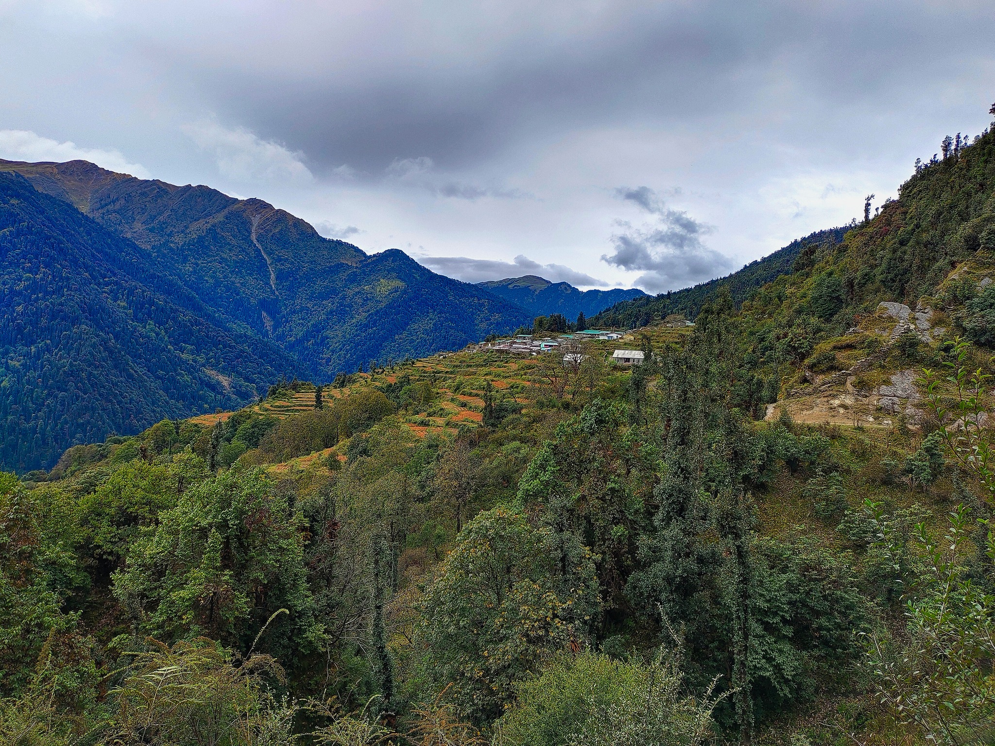
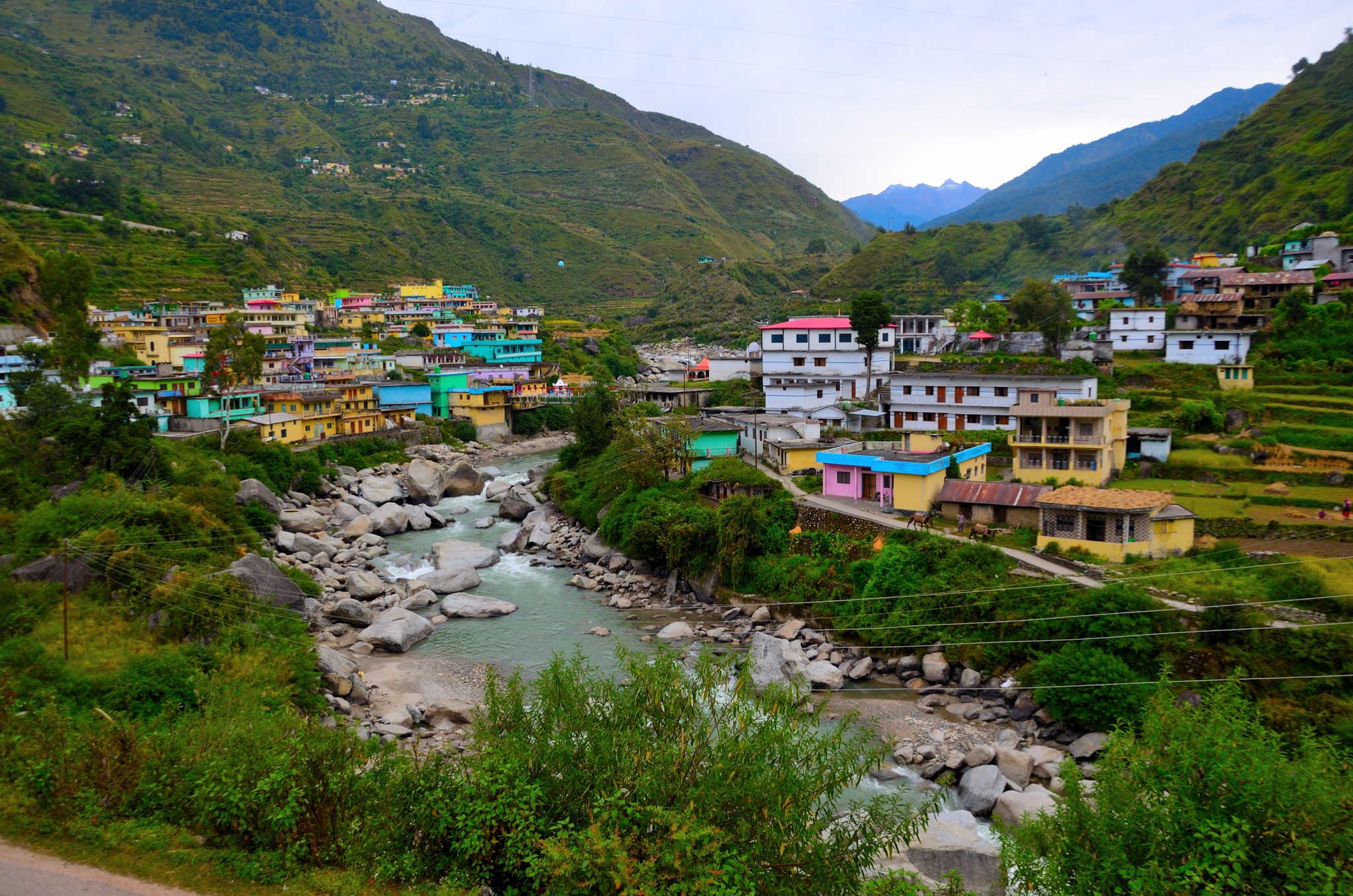
From Ghuttu, the road continues further into isolation, eventually reaching Gangi — now accessible by road, yet still retaining its raw, untouched character. Surrounded by steep forested slopes and the constant flow of the Bhilangana river below, Gangi feels like the true beginning of the expedition. As evening sets in, the stillness of the valley takes over, marking the transition from journey to trek.
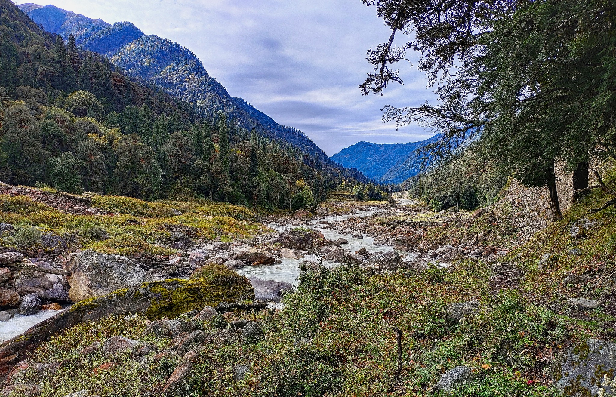
The trek begins straight out of Gangi, quickly entering a dense forest of pine and rhododendron that sets the tone for the journey ahead. The trail feels raw and undisturbed, with sections that are narrow, uneven, and constantly shifting underfoot. The Bhilangana river remains close by, its force unmistakable — loud, restless, and always present somewhere below the trail.
Within a couple of hours, you pass Dhakuli — a small settlement that appears almost abandoned. The silence here feels unusual, as if the village has been left behind by time. Beyond this point, the wilderness deepens. The forest thickens, the trail becomes more rugged, and the sense of isolation begins to settle in.
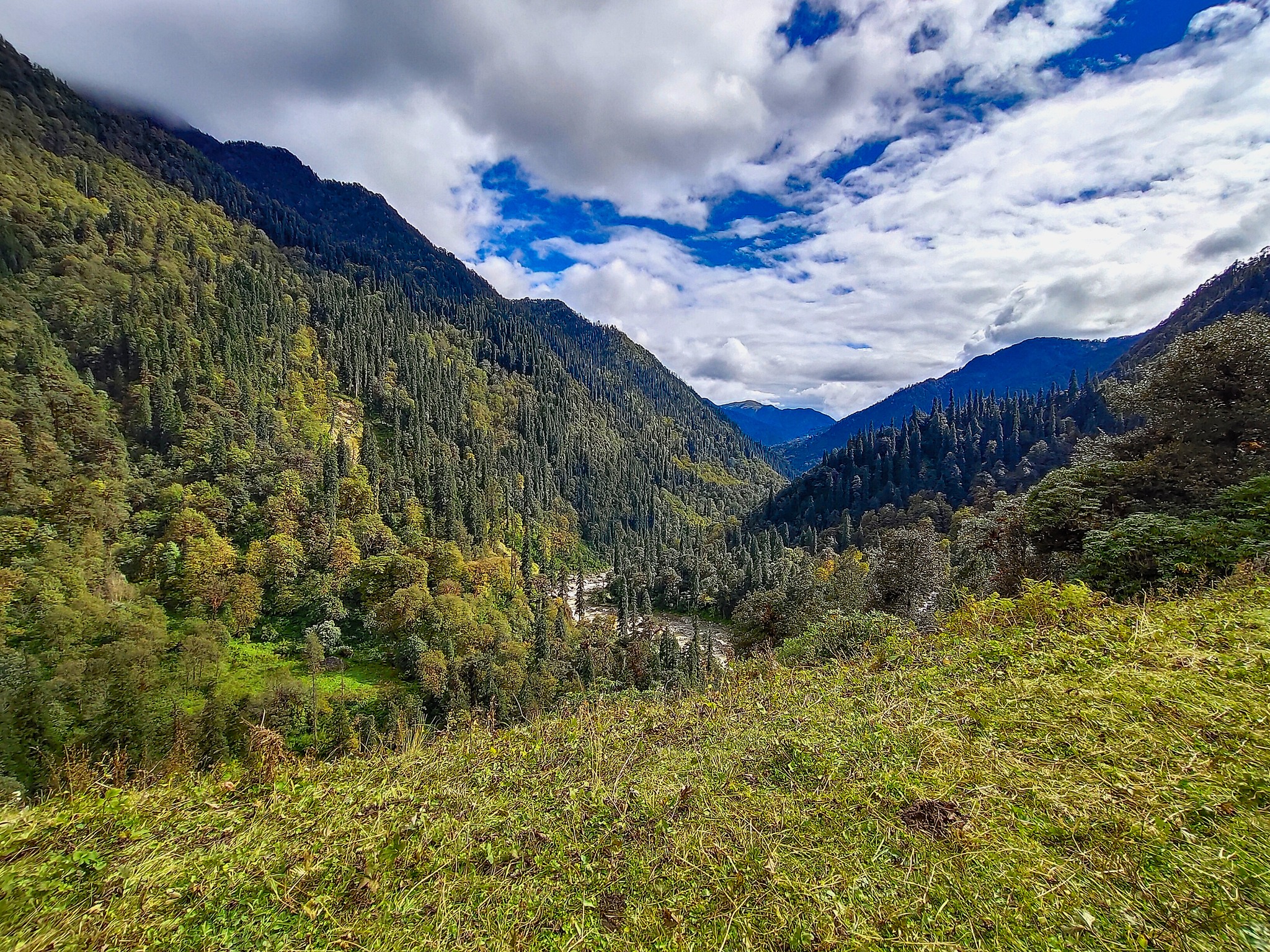
For most of the day, you continue along the Bhilangana valley, walking parallel to the river, occasionally descending toward it before climbing back up along the slopes. The terrain is not overly steep, but it demands steady movement and attention, especially with loose sections and broken patches along the way.
The final stretch to Kalyani is a steady climb, gaining height through dense forest before the landscape suddenly opens out. Kalyani appears as a wide, open meadow — a surprising contrast after hours of enclosed forest. Surrounded by towering ridgelines and backed by thick woodland, the campsite feels both exposed and protected at the same time.
It’s here that the rhythm of the trek begins to take shape — long days, changing terrain, and the constant presence of the river guiding your way deeper into the mountains.
The trail continues deeper into the Bhilangana valley, maintaining a steady rhythm through a mix of dense forest and sudden meadow openings. The landscape feels more alive here — multiple small tributaries cut across the trail, feeding into the Bhilangana river below. Each crossing adds a pause, a moment to assess footing, as the terrain remains constantly shifting.
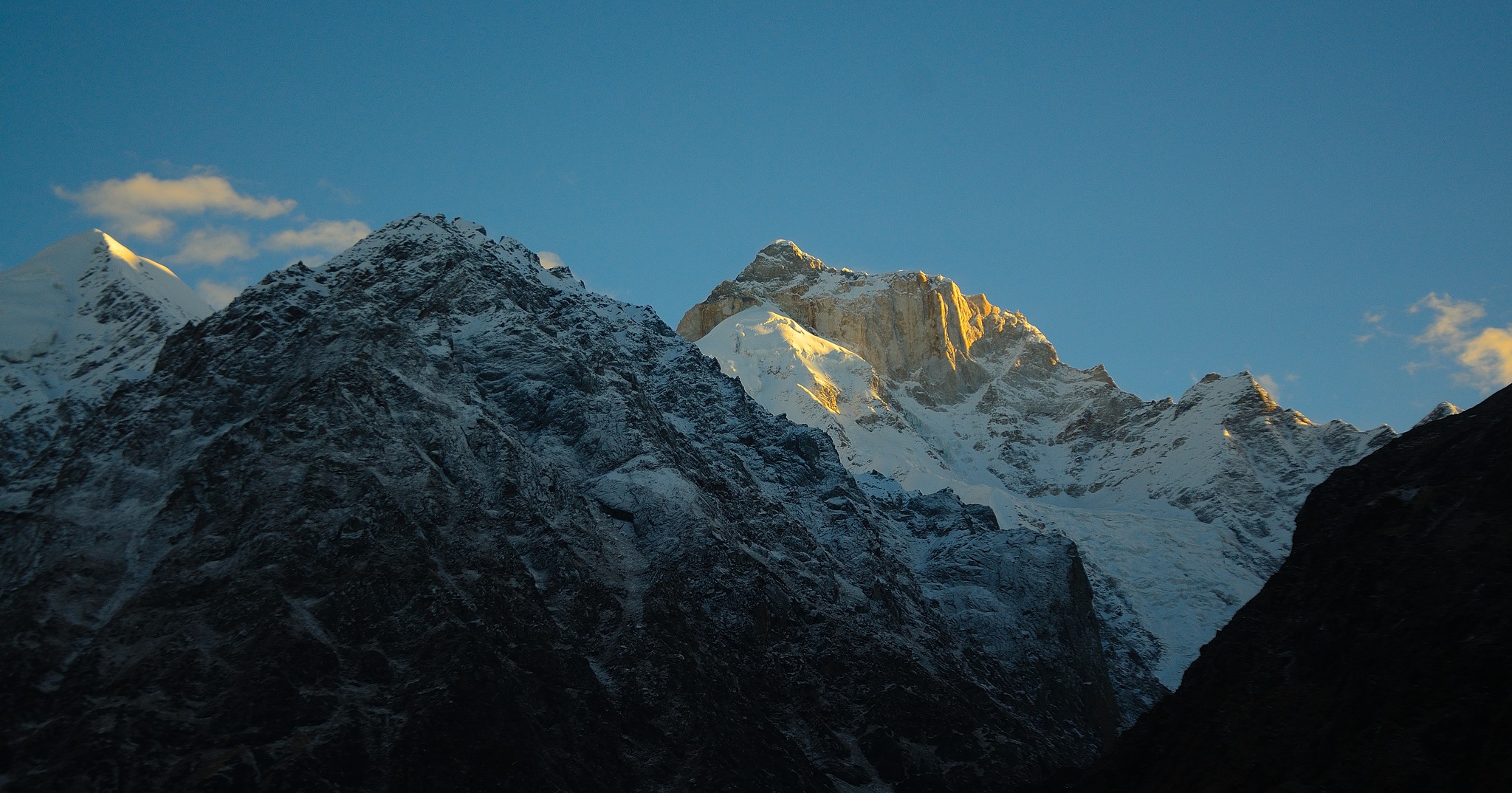
The valley begins to reveal its scale today. As the forest briefly opens up, you get your first distant views of towering peaks like Thalaysagar and Meru rising sharply in the distance — stark, dramatic, and unmistakably high Himalayan. These glimpses come and go, often hidden behind ridgelines and clouds, but they mark a clear transition into more serious terrain.
The trail itself is not always forgiving. Sections along the Bhilangana river pass through landslide-prone zones where the path narrows and the ground feels unstable. These stretches demand careful movement and awareness, especially in loose or freshly eroded sections.
Between these exposed patches, the forest returns — quieter, denser, and occasionally giving way to small meadows that offer brief relief. The contrast between enclosed forest and open valley keeps the day visually engaging, never allowing the terrain to feel repetitive.
By late afternoon, you arrive at Kharsoli — a peaceful campsite set amidst a mix of forest and open ground. With the sound of distant water and the first real presence of high peaks around you, the campsite feels like a transition point — where the valley begins to shift from forested comfort toward the harsher terrain that lies ahead.
The trail continues along the Bhilangana valley, but the character of the terrain begins to change from today. The initial stretch feels familiar — moving through a mix of forest sections and open clearings, with the river still guiding your direction somewhere below. The valley remains beautiful, but there is a noticeable shift in effort.
Gradually, the climb begins.
What starts as a steady ascent soon turns steeper, pulling you higher above the valley floor. The trail narrows in sections, cutting across slopes that demand more careful footing. The forest begins to thin out intermittently, opening into wider views of the valley you’ve been walking through over the past few days.
The sound of the river fades slightly as you gain altitude, replaced by a quieter, more exposed atmosphere. The terrain feels more committing now — longer stretches without easy relief, and a steady gain in height that begins to make its presence felt.
As you approach Tambakund, the landscape opens into a high-altitude basin surrounded by rising ridgelines. The campsite sits in a vast, open setting — quieter, more exposed, and clearly deeper into the mountains than anything before.
By now, the transition is evident. The dense forests are slowly giving way, the climbs are becoming more sustained, and the trek is steadily moving toward harsher, more alpine terrain.
Though shorter in distance, today is one of the most crucial transitions of the trek. The day begins by continuing along the upper Bhilangana valley, but very soon, the route demands a river crossing — a defining moment of the day.
Depending on conditions, this can be done via a temporary shepherd’s wooden bridge, if available and stable. At times, this bridge may not be usable, in which case the route involves moving further ahead toward Zero Point to find a safer crossing, before traversing back toward Chowki. The river here is powerful, fed directly by glacial melt, and demands complete caution.
Once across, the climb begins immediately.
A steep ascent pulls you sharply above the valley floor, gaining altitude quickly and cutting across rugged slopes. The effort is short but intense — the kind that makes you stop, breathe, and look back more often than usual. As you gain height, the valley you’ve been walking through begins to reveal itself in full scale.
And then, almost suddenly, the terrain opens.
Chowki.
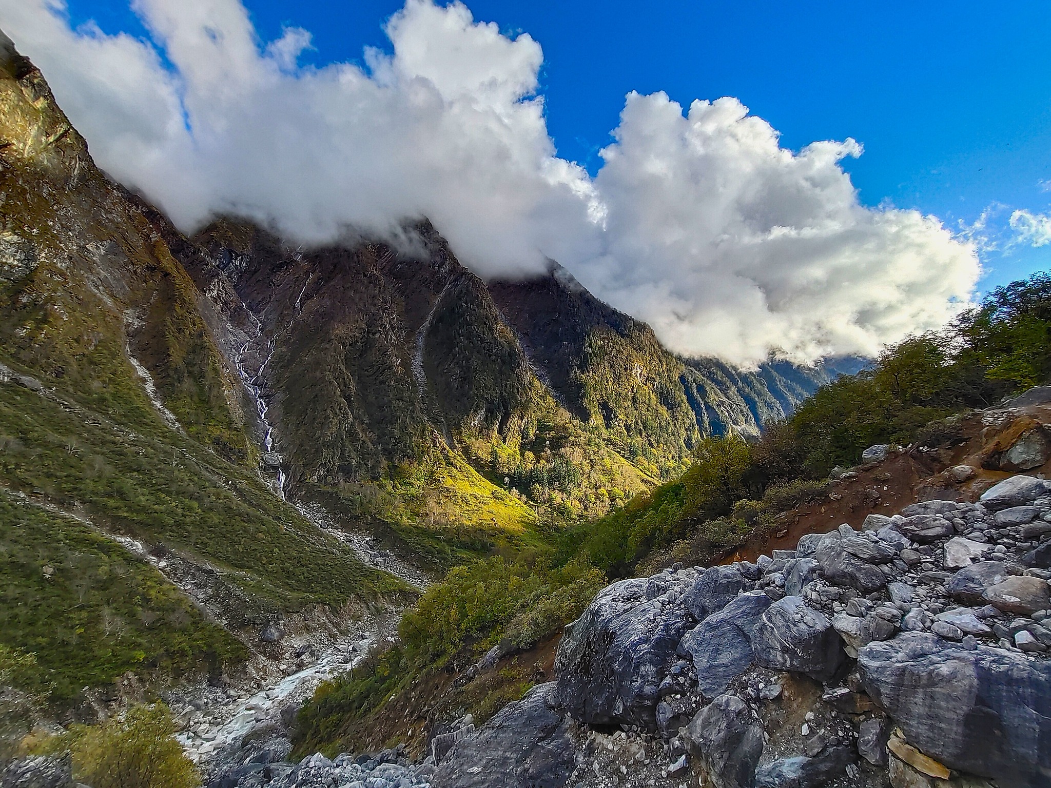
A vast meadow set deep within wild Himalayan terrain, surrounded by towering peaks on all sides. The Bhilangana river continues to flow far below, now seen in its entirety as it emerges from the visible snout of the Khatling Glacier — a raw, glacial landscape that dominates the horizon ahead.
From here, the mountains begin to show their true scale. Peaks like Thalaysagar, Jogin, and others rise sharply beyond the basin, often partially hidden behind shifting clouds. Turn around, and the entire valley you’ve ascended stretches endlessly behind you — layered, deep, and almost unreal in its scale.
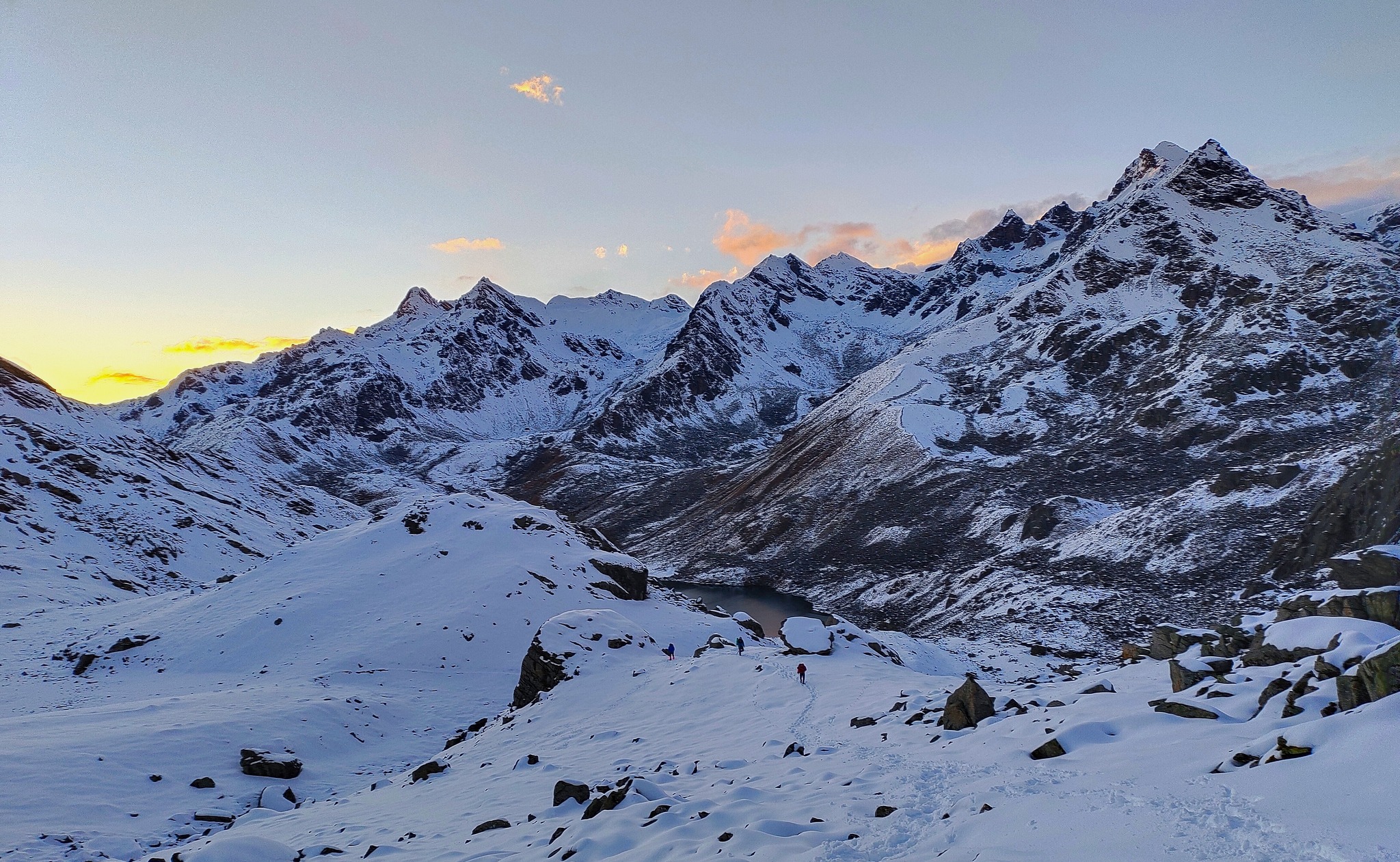
Chowki is not just a campsite — it is a viewpoint in itself. As evening approaches, the meadow transforms under changing light. The landscape takes on shades of yellow, green, and brown, while the surrounding peaks glow under crimson sunset hues. Sunrise here feels just as surreal, with first light slowly revealing the vastness around you.
But this is also where the mountains begin to change their mood.
From Chowki onward, weather becomes highly unpredictable. Clear skies can turn within minutes, winds can rise without warning, and conditions can shift rapidly. It is a place that demands awareness — where every step forward must be balanced with caution, and every moment of beauty observed with respect for the terrain.
The comfort of the lower valleys is now far behind. What lies ahead is far more exposed, far more demanding, and entirely at the mercy of the mountains.
From today onward, the trek steps fully into its most demanding phase.
The climb begins right out of Chowki — steep, continuous, and unrelenting. There is no gradual build-up anymore. The trail gains altitude quickly, cutting across exposed slopes and broken terrain where footing needs to be deliberate and steady.
The valley behind slowly drops away, and the route ahead feels more rugged with every step. Vegetation thins rapidly, giving way to a harsher alpine landscape where rock, loose soil, and scattered snow patches begin to dominate.
As you gain height, the weather becomes a decisive factor.
Clouds can roll in without warning, reducing visibility to dangerous levels. In such conditions, the trail can easily disappear into the terrain, making navigation difficult. This is a day where staying together is not optional — it is essential. Movement becomes slower, more cautious, and fully dependent on group coordination.
The climb demands both physical and mental focus. There are no easy sections to recover — only a steady push upward through terrain that feels increasingly isolated and exposed.
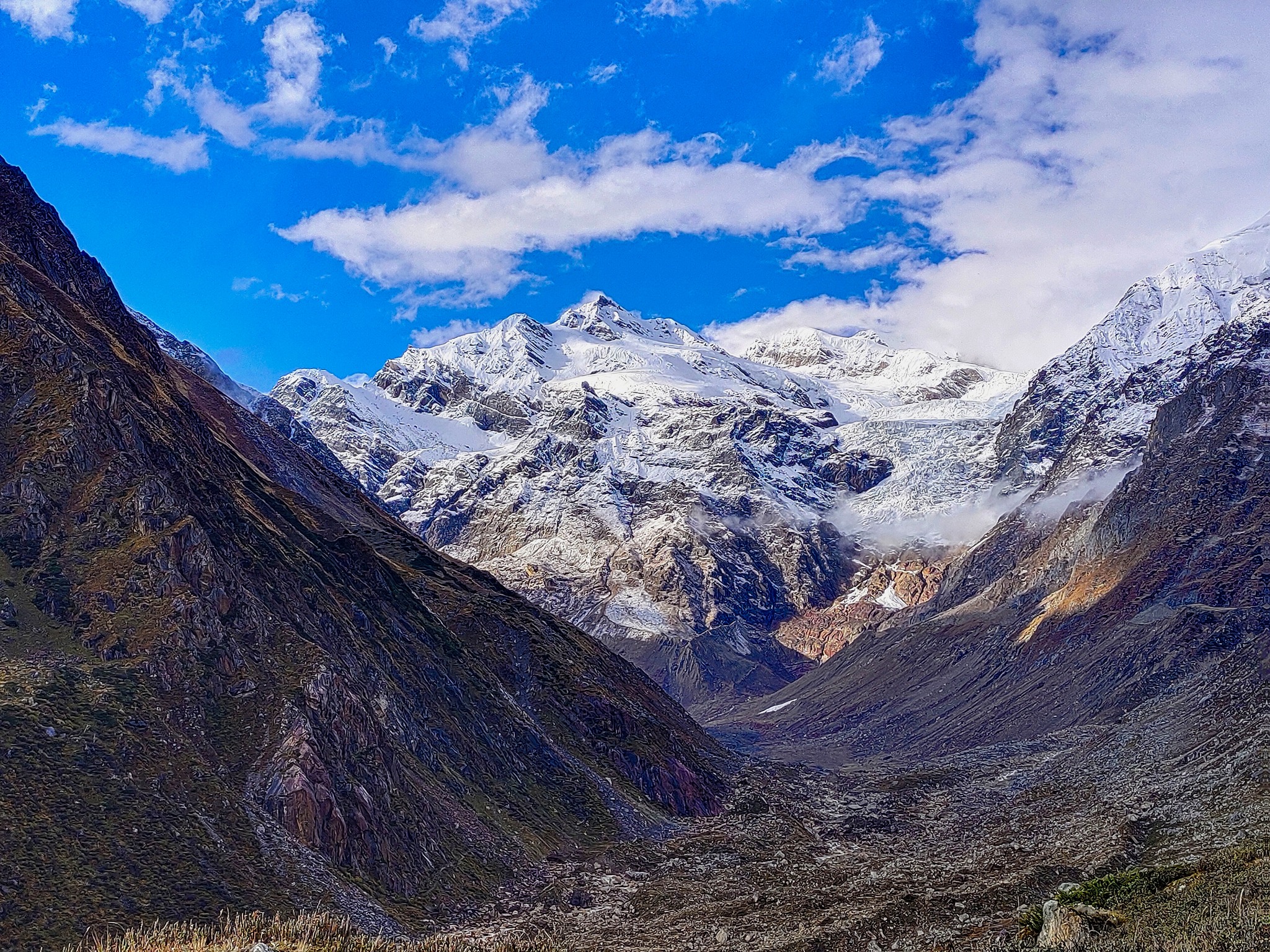
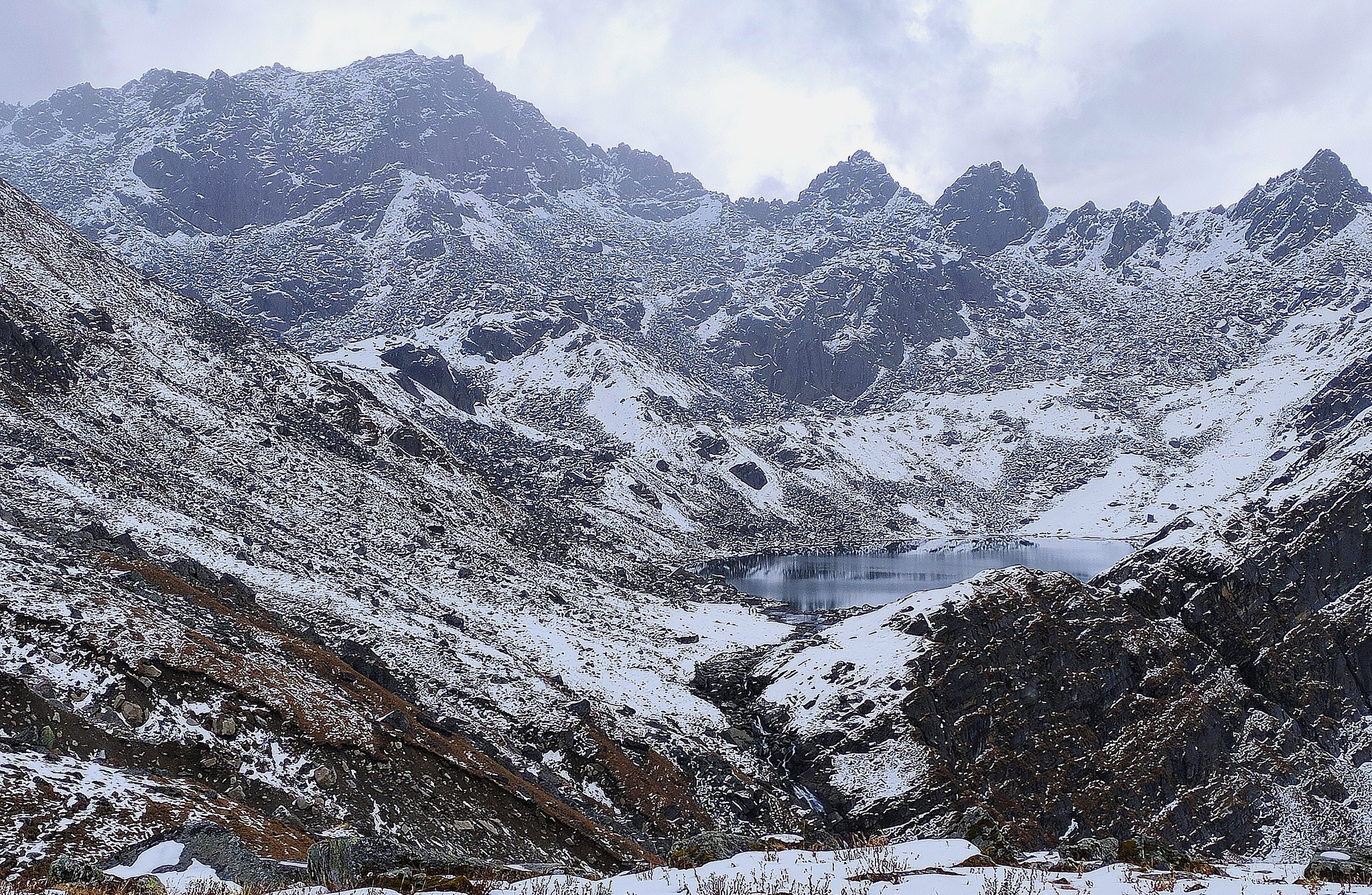
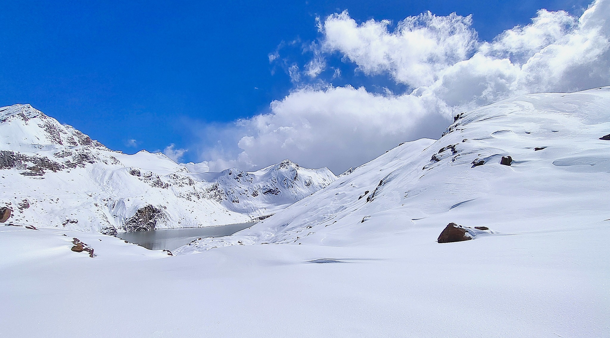
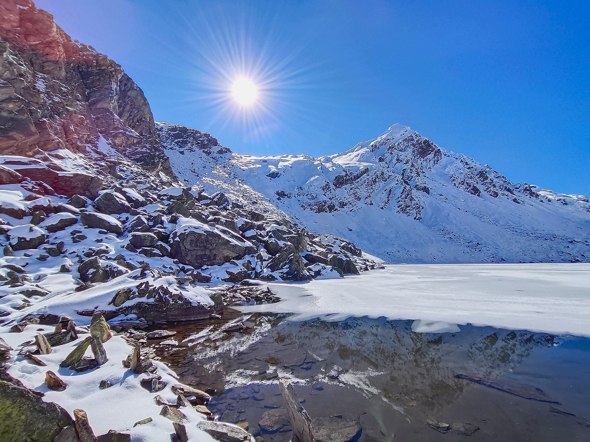
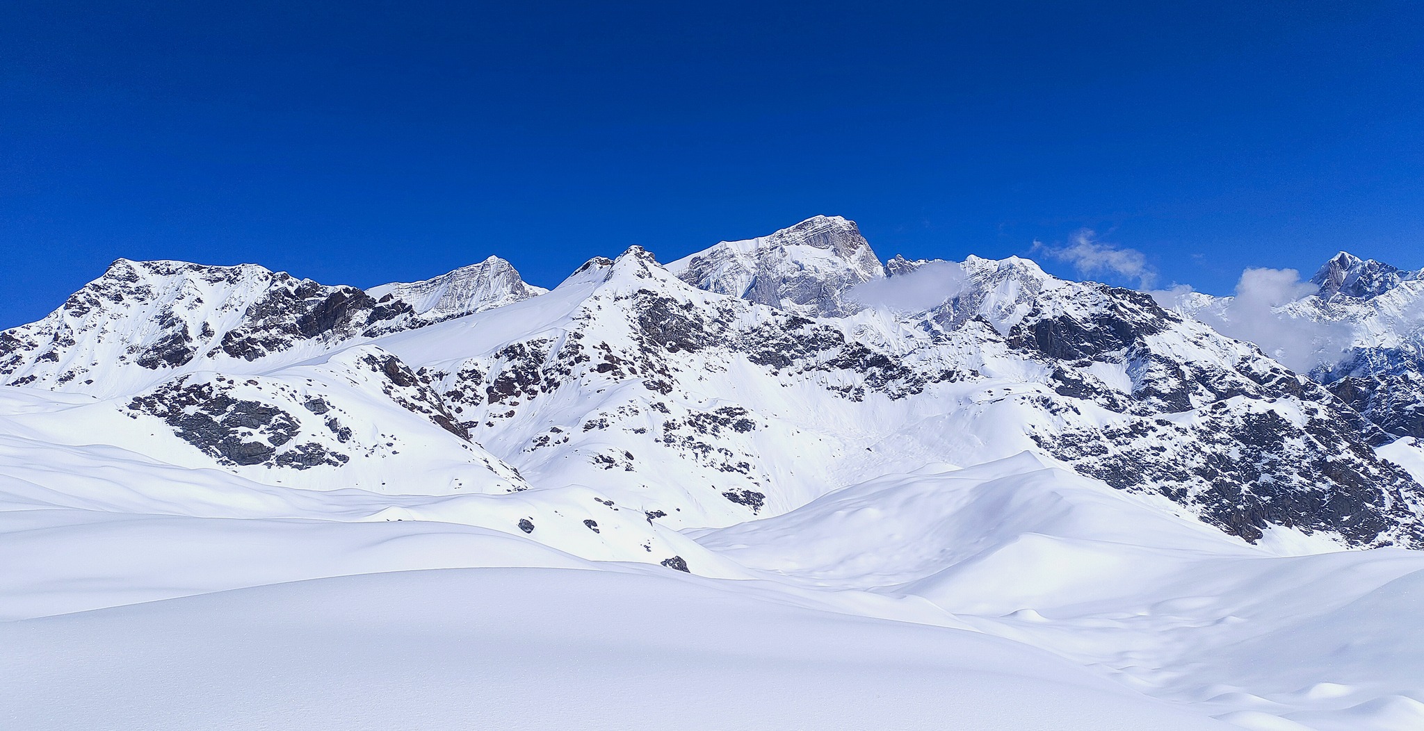
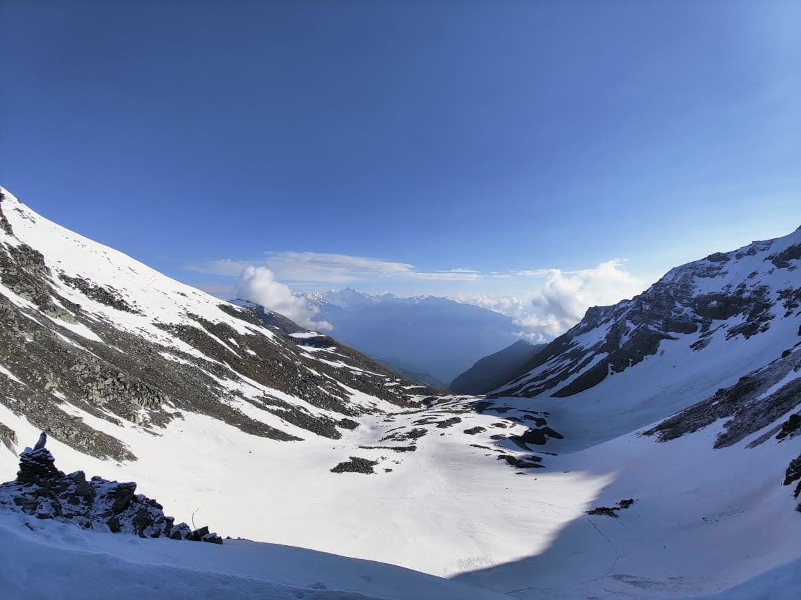
By the time you reach Masar Tal, the landscape has completely transformed.
The lake sits quietly amidst this rugged terrain — cold, still, and surrounded by rising slopes and distant ridgelines. There is a starkness to this place, a silence that feels deeper than anything encountered so far.
This is not just another campsite.
It marks the beginning of the true high-altitude traverse — where conditions, terrain, and effort all come together to define the journey ahead.
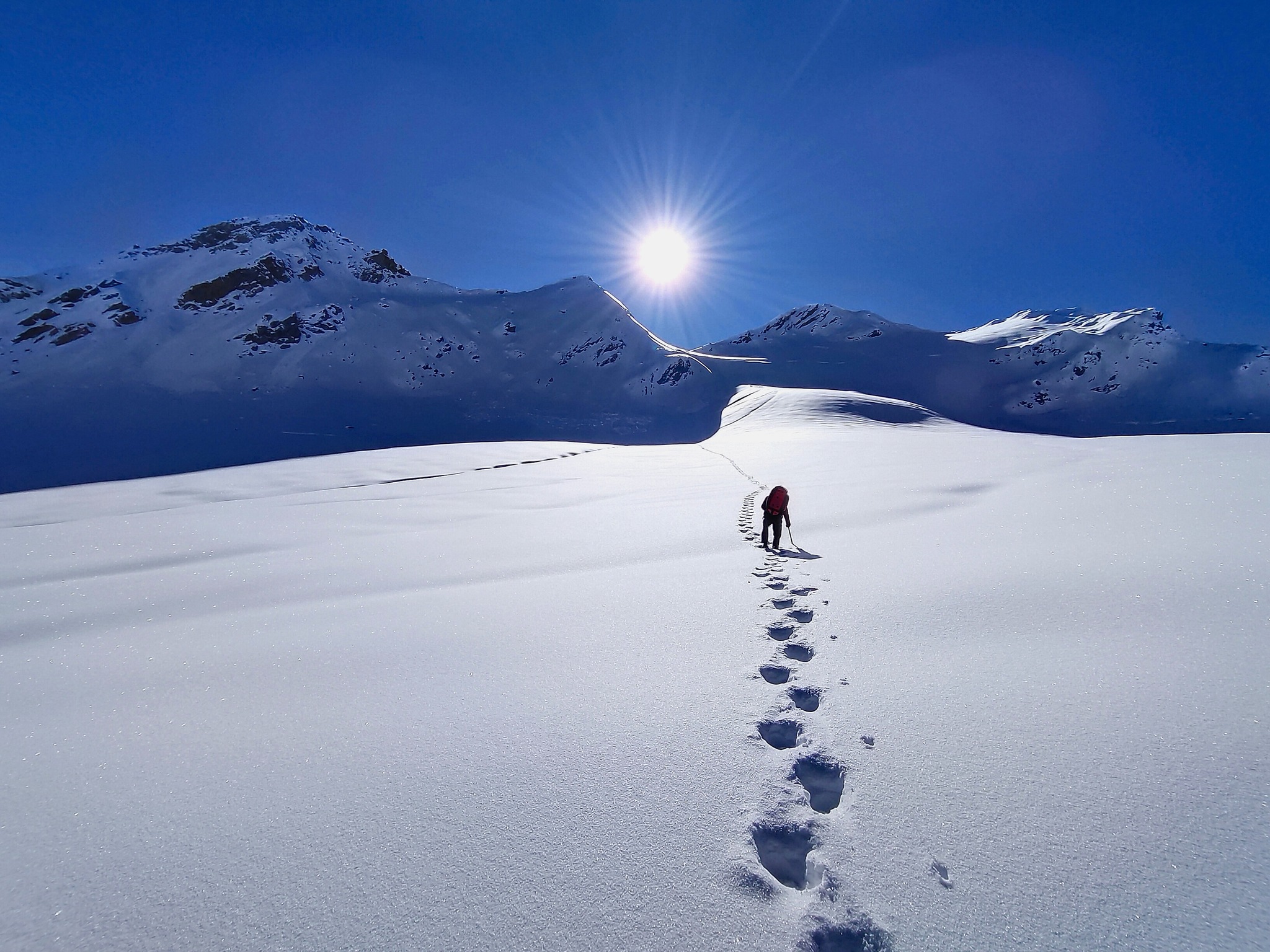
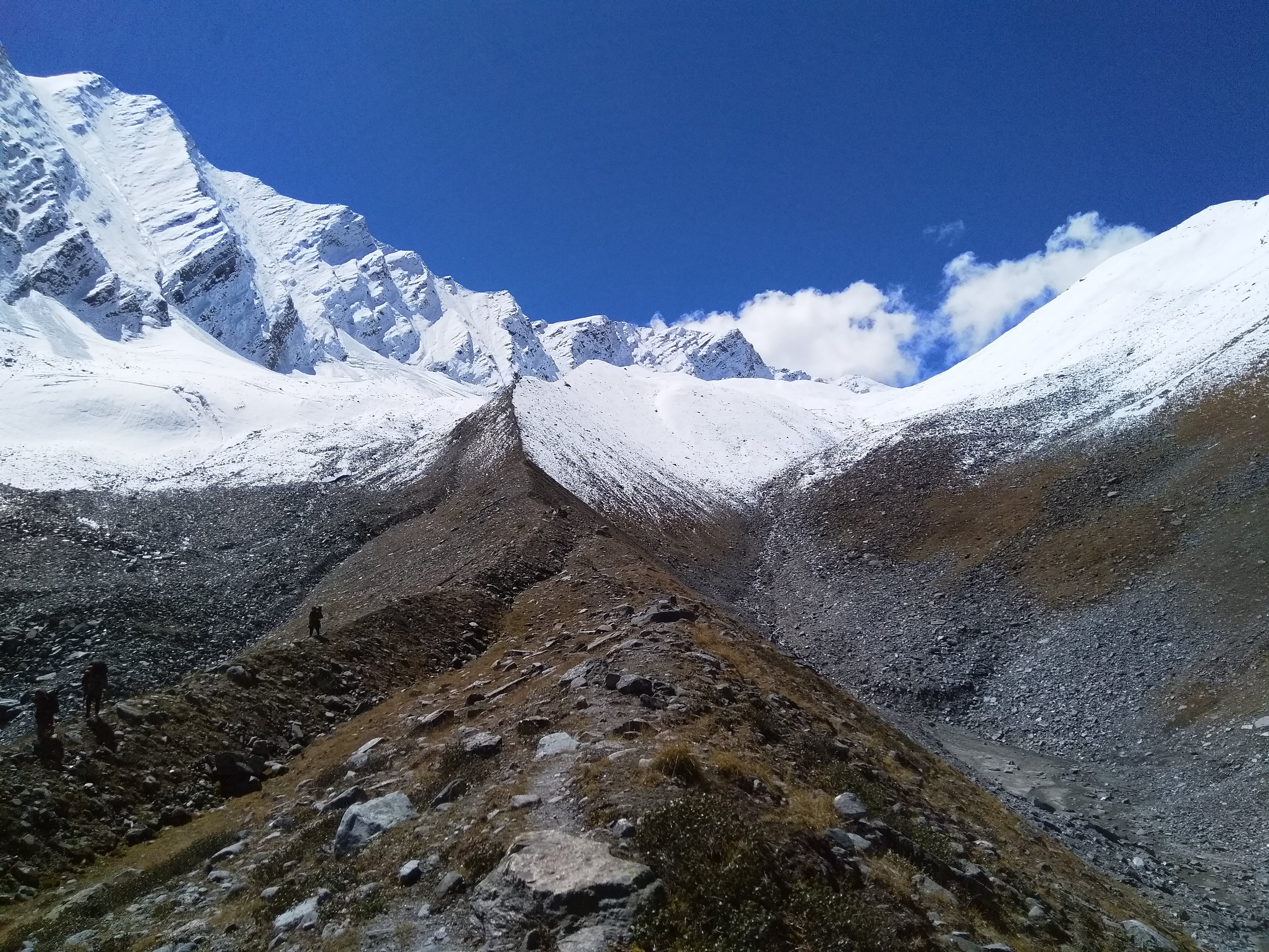
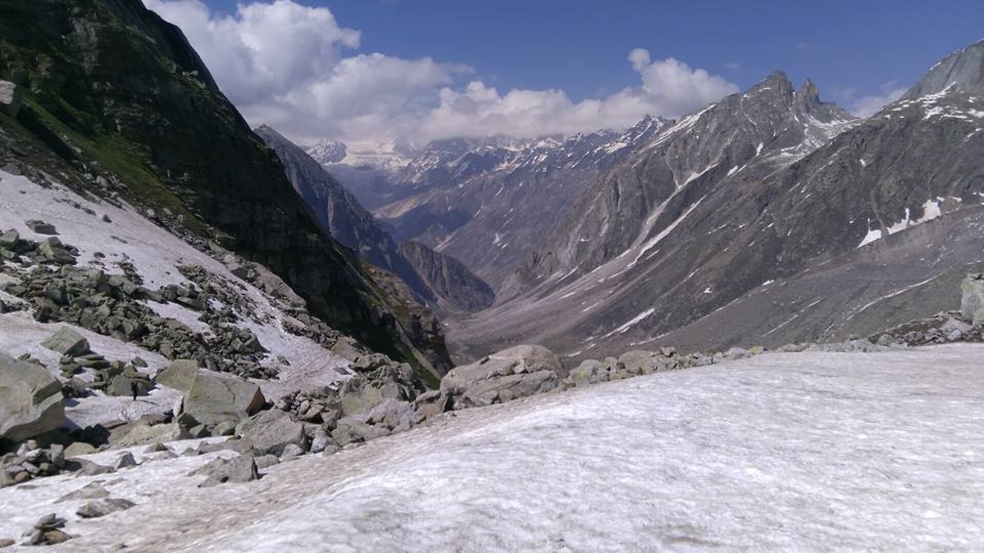
This is the longest and most demanding day of the entire trek — the crossing of Mayali Pass.
The day begins early, often before sunrise, with a steady climb toward Masar Top. The ascent is steep right from the start, moving across loose rock, snow patches, and broken moraine. As you gain height, the landscape becomes completely barren — stripped down to rock, ice, and sky.
Beyond Masar Top, the terrain opens into a high glacial basin where Paiyan Tal appears — a silent, high-altitude lake set amidst cold, rugged surroundings. It feels momentary, almost unreal, before the route pushes further into harsher terrain.
What follows is a long, continuous stretch across the Mayali icefield.
For nearly 2 kilometers, the route climbs gradually but relentlessly over snow and glacial terrain. The surface conditions vary — from hard-packed snow to softer sections that demand careful footing. The altitude begins to weigh heavily, slowing movement and stretching effort over time.
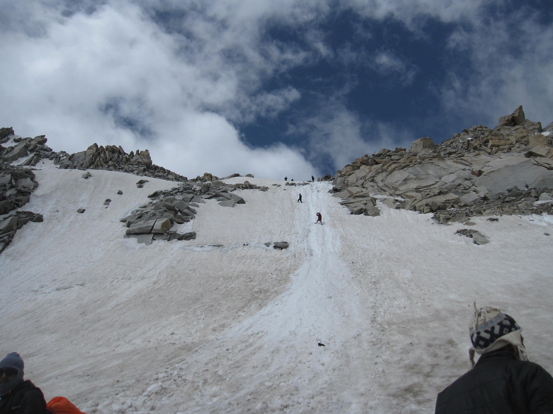
The final push to the pass is steady and exposed.
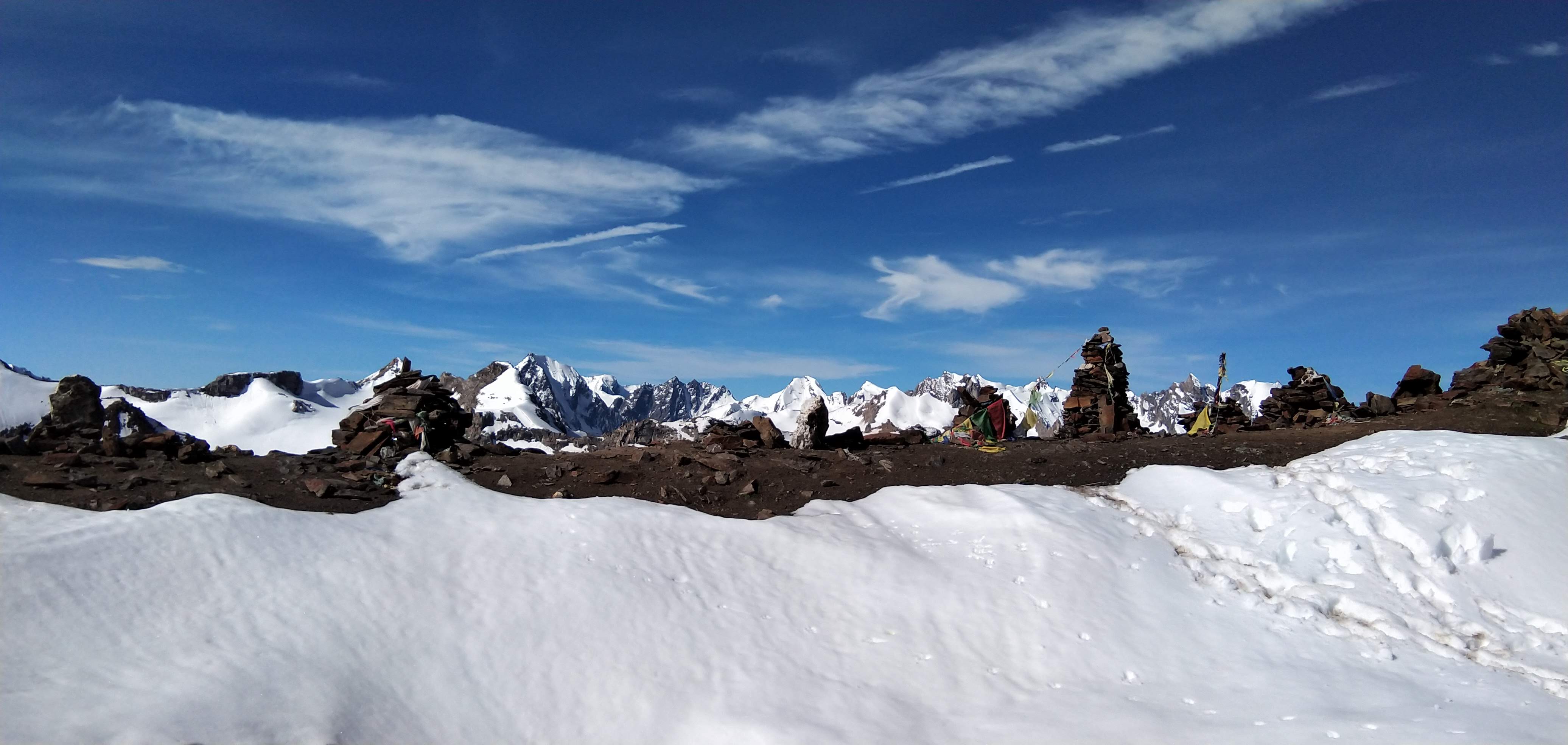
At around 17,390 ft, Mayali Pass stands as a high, wind-swept crossing — raw, silent, and completely at the mercy of weather. Views, if clear, stretch across both sides — the glaciated expanse of the Bhilangana side behind you, and the rugged drop into the Kedarnath valley ahead.
But there is no pause for long.
The descent begins immediately — and it is unforgiving.
A steep, treacherous drop pulls you sharply down from the pass, often across snow slopes and loose rock. Depending on conditions, this section may require technical assistance, including ropes, as footing can be unstable and exposed. Each step demands focus, patience, and control.
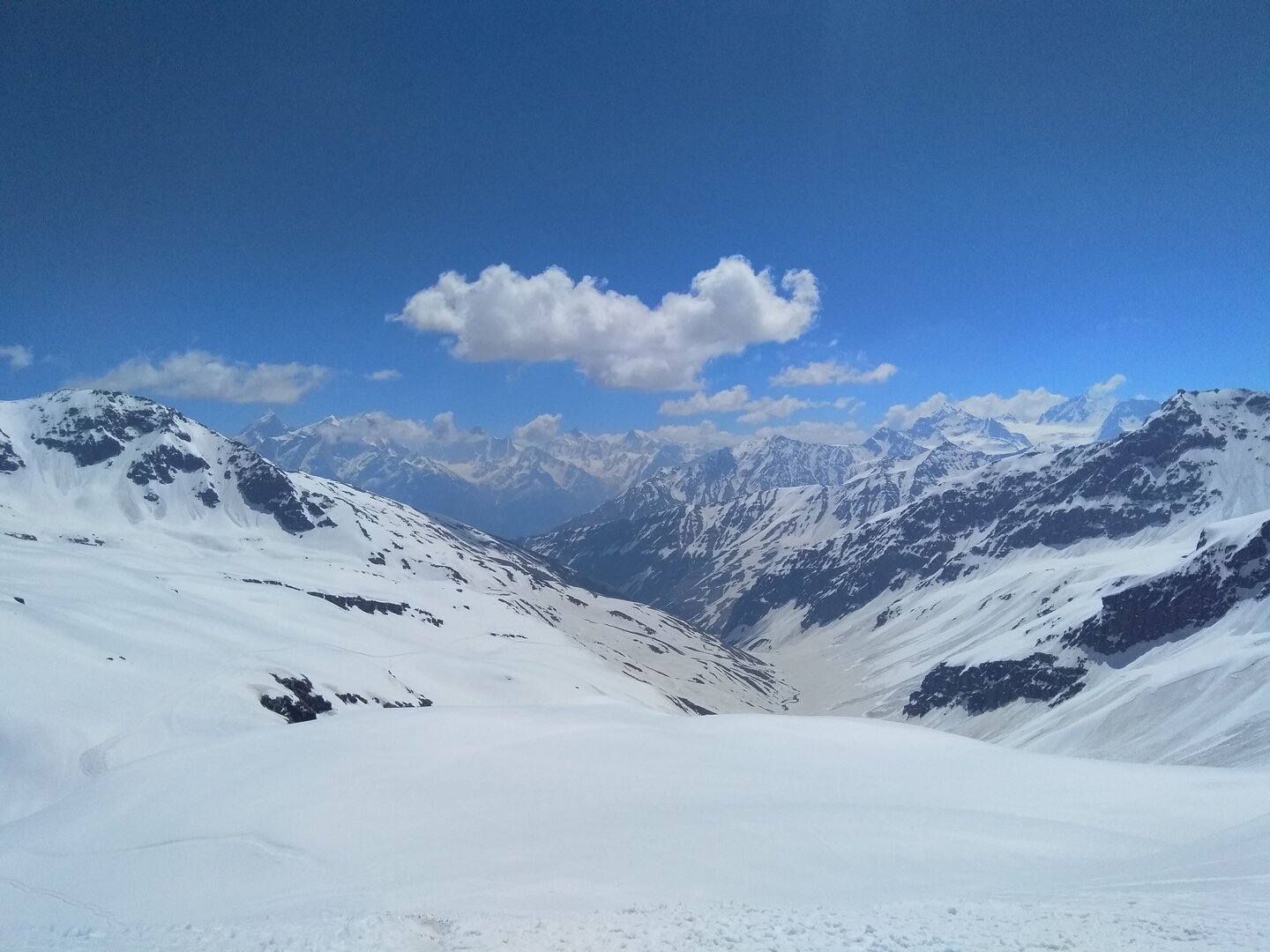
The descent continues for 3–4 km, gradually easing as altitude is lost and the terrain begins to open toward the Mandakini basin.
By the time you reach Vasuki Tal, the contrast feels immense.
Set beneath towering peaks of the Kedarnath region, the lake rests in a vast high-altitude basin — calmer, yet still deeply connected to the raw terrain you’ve just crossed. After a long and committing day, the campsite feels earned.
This is not just another day of trekking.
It is the crossing — where the Bhilangana valley is left behind, and the journey enters the sacred terrain of Kedarnath.
After the intensity of the pass, today offers a different kind of movement — still high in the mountains, but with a gradual transition toward a more defined trail.
The day begins with a short ascent from Vasuki Tal, climbing over a series of humps toward Vasuki Top. The terrain remains rugged, with a mix of rocky ground and open stretches, but the gradient is more forgiving compared to the previous day.
As you gain this final height, the landscape opens dramatically.
From Vasuki Top, the first clear views of the Kedarnath valley appear — a vast, glacially carved basin surrounded by towering peaks of the region. The contrast is immediate. After days of isolation in the Bhilangana valley and the harsh crossing of Mayali Pass, the sight of this broader, more open valley feels almost surreal.
The descent begins gradually, moving across high-altitude terrain that slowly transitions into a more defined path. As you lose altitude, signs of human movement begin to reappear — faint trails, distant structures, and eventually, the unmistakable presence of pilgrims.
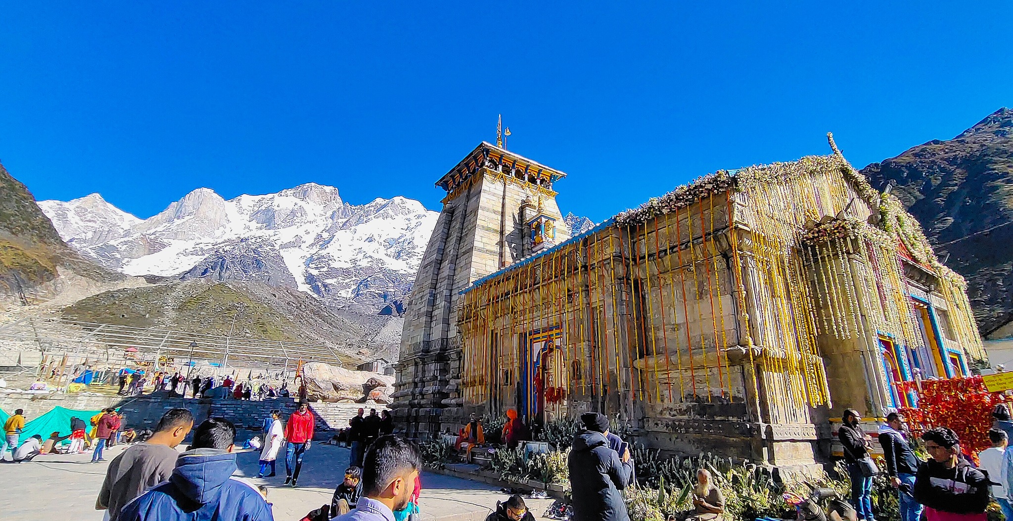
The final approach to Kedarnath brings a unique shift in atmosphere.
After days spent in complete wilderness, the sudden presence of people, movement, and sound feels striking. The Kedarnath Temple, standing at 11,755 ft against the dramatic Himalayan backdrop, marks not just the end of a trail, but a powerful transition — from isolation to devotion.
Reaching here after crossing one of the most remote high-altitude passes in the region carries a different weight altogether. The journey does not just end — it settles.
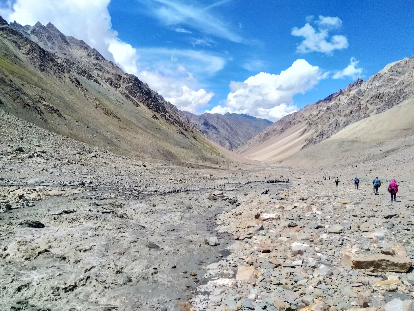
The final day begins with a long descent along the well-defined Kedarnath pilgrimage trail. The path is clearly marked and steadily descends alongside the Mandakini river, passing through key points like Rambara — a place that still carries the memory of the 2013 floods.
Compared to the previous days, the trail feels structured and active, with a constant flow of pilgrims moving in both directions. Stone-paved sections, railings, and rest points make the descent more straightforward, though the distance ensures that it remains physically demanding on the knees.
As you continue descending, the air grows warmer and thicker, and the high mountain silence gradually gives way to the sounds of human movement, conversations, and the river flowing stronger with every kilometer.
By the time you reach Gaurikund, the transition feels complete. Roads, vehicles, and the presence of the outside world return after days of complete isolation in the high Himalayas.
A short drive from Gaurikund brings you to Sonprayag (6,000 ft), marking the true end of the journey. From raw glacial terrain and silent high-altitude crossings to a structured pilgrimage route, the trek comes full circle — leaving behind a journey that feels far greater than the distance covered.
This day is reserved to account for any delays during the trek, especially around the Mayali Pass crossing. Weather in this region is highly unpredictable, and conditions such as heavy snowfall, low visibility, or unsafe terrain can impact movement and timing.
The buffer ensures flexibility in the itinerary, allowing the team to wait for safer conditions if required, without compromising the overall plan. It also acts as a safety margin in case of slower progress across technical sections or extended halts due to river crossings or route conditions.
✅The Bhilangana valley, from where the trek begins, remains one of the least explored regions in Garhwal, with Gangi village acting as a rare gateway into this isolated landscape.
✅The forests between Gangi and Tambakund are rich in Himalayan biodiversity, home to species like Himalayan black bear, musk deer, and monal, with dense oak, pine, and rhododendron cover dominating the lower altitudes.
✅Khatling Glacier, visible from the Chowki region, is one of the most heavily glaciated and complex glacier systems in the Garhwal Himalayas, known for its unstable terrain and hidden crevasses.
✅The glacier basin connects to technical high-altitude routes like Auden’s Col, where climbers must navigate crevasse fields, ice walls, and exposed glacier crossings to reach the Gangotri side.
✅The Mayali Pass (~17,390 ft) itself is a non-technical but highly demanding crossover, where route conditions change every season due to shifting snowfields, moraine movement, and glacial retreat.
✅Sacred high-altitude lakes like Masar Tal, Paiyan Tal, and Vasuki Tal are not just scenic landmarks but hold deep spiritual significance in local belief systems, often associated with purity and divine presence.
✅Vasuki Tal, located near Kedarnath, is believed to be the place where Lord Vishnu is said to have bathed, and it remains one of the most sacred high-altitude lakes in the region.
✅The transition from Bhilangana valley to Kedarnath valley marks a dramatic geological and ecological shift — from dense forested isolation to a more open, glacially carved basin with established pilgrimage routes.
✅On clear days, the trek offers rare close-range views of some of the most iconic and technically challenging peaks in the Indian Himalayas, including Thalaysagar, Meru, Jogin group, Kedarnath Peak, Kedardome, Kedar Kharak, Trishul, and the Chaukhamba massif.
✅Thalaysagar and Meru, visible from the Bhilangana side, are among the most sought-after peaks for technical climbers worldwide due to their steep granite faces and complex routes.
✅Unlike many treks, Mayali Pass does not follow a single well-defined trail — sections of the route require constant terrain reading, especially across moraine, snowfields, and glacial basins.
✅Weather in this region is heavily influenced by the glacial systems around Khatling, often leading to sudden cloud build-up, whiteouts, and rapid temperature drops even during stable seasons.
✅Kedarnath, the endpoint of the trek, is one of the twelve Jyotirlingas of Lord Shiva, and its current temple is believed to have been revived by Adi Shankaracharya in the 8th century.
✅The contrast of reaching Kedarnath after days of complete wilderness is unique — from absolute isolation in high-altitude terrain to one of the most spiritually active sites in the Himalayas within a single journey.
Route Map
How to reach
✈️ Air: • Nearest Airport: Jolly Grant Airport, Dehradun (DED) • Well connected with major cities like Delhi, Mumbai, Bangalore, and others. • From the airport, you can hire a taxi to Rishikesh or directly toward Ghuttu/Gangi (limited direct options).
🚆 Train: • Nearest Railway Station: Rishikesh / Haridwar • Both stations are well connected with Delhi and other major cities. • From here, you can continue your journey by road toward Ghuttu and Gangi.
🛣️ Road:Rishikesh to Gangi (~210 km | 9–10 hours via Tehri – Ghuttu)
🗺️ Travel Tip: • Private Cab: The most reliable and comfortable option. Can be booked from Rishikesh/Dehradun for a direct journey to Gangi. Ideal for groups and ensures flexibility in timing. • Shared Vehicles / Public Transport: Available till Ghuttu via local buses or shared jeeps from Rishikesh/Tehri. From Ghuttu to Gangi, transport options are limited and may require hiring a local jeep on the spot. • It is advisable to start early in the morning, as mountain roads are long and conditions can vary.
Gallery
TrekFAQs
Mayali Pass is strictly for experienced trekkers. You must have prior high-altitude trekking experience (14,000 ft+) and be comfortable with long, demanding days in remote terrain. This trek is not suitable for beginners due to its unpredictability, terrain complexity, and exposure to harsh conditions.
This is a difficult to expedition-grade trek. It involves a high-altitude pass (~17,390 ft), long trekking hours (8–12 hrs on key days), steep ascents, glacial traverses, river crossings, and unstable terrain. The stretch from Chowki to Vasuki Tal is particularly demanding, both physically and mentally.
Unlike many structured treks, Mayali involves constant terrain variation, minimal defined trail in upper sections, unpredictable weather, and long committing stretches without exit options. The crossing from Masar Tal to Vasuki Tal via the pass includes glacier travel, steep descent, and exposure to rapidly changing conditions.
The trek begins with dense forests and river valleys, transitions into alpine meadows, and then moves into rugged high-altitude terrain including moraine, glacial basins, snowfields, and steep descents. Frequent river crossings and landslide-prone sections add to the complexity.
It is not a fully technical climb but involves technical sections depending on conditions. The descent from the pass toward Vasuki Tal can be steep and treacherous, sometimes requiring rope support. Basic snow-walking skills, balance on loose terrain, and strong endurance are essential.
Key risks include AMS (Acute Mountain Sickness), sudden weather changes, whiteouts, river crossing hazards, landslides, and slips on snow or loose moraine. The remoteness of the Bhilangana valley makes evacuation difficult, increasing the importance of preparedness and experienced leadership.
Weather in the Mayali region is highly unpredictable, especially beyond Chowki. Clear skies can turn into complete whiteouts within minutes. Cloud build-up, strong winds, and sudden snowfall are common due to the influence of the Khatling glacier system.
The stretch from Chowki to Vasuki Tal via Masar Tal and Mayali Pass is the most demanding. It involves steep climbs, glacier traversal, navigation challenges, and a long, exposed descent into the Kedarnath valley. This section defines the difficulty of the trek.
Lower sections feature dense forests of oak, pine, and rhododendron, rich in biodiversity. Wildlife sightings may include Himalayan black bear, musk deer, and monal. As altitude increases, vegetation reduces drastically, transitioning into alpine and glacial landscapes.
The trek passes through several sacred high-altitude lakes including Masar Tal, Paiyan Tal, and Vasuki Tal. These lakes are not only scenic but hold deep spiritual significance and are rarely visited compared to other Himalayan lakes.
On clear days, the trek offers spectacular views of iconic peaks like Thalaysagar, Meru, Jogin group, Kedarnath Peak, Kedardome, Kedar Kharak, Trishul, and Chaukhamba massif. These are among the most prominent and technically challenging peaks in the Indian Himalayas.
The Bhilangana valley is one of the most remote and least explored regions in Garhwal. It offers raw wilderness, minimal human presence, and a deep sense of isolation, making the initial days of the trek uniquely immersive.
Kedarnath, one of the twelve Jyotirlingas of Lord Shiva, marks the spiritual culmination of the trek. Reaching it after days of complete wilderness creates a powerful contrast — from isolation in the high mountains to one of the most sacred pilgrimage sites in India.
You should be able to run 5 km in 30 minutes and sustain long trekking days of 8–10 hours. Strong cardiovascular fitness, endurance, and mental resilience are essential due to the demanding nature of the trek.
Preparation should include cardio training (running, cycling), strength training (legs and core), and endurance building (long hikes with load). Training should begin at least 6–8 weeks before the trek.
Yes, it is strongly recommended. Trekkers without prior exposure above 12,000–14,000 ft may struggle with acclimatization and terrain challenges.
Network is available till Gangi (limited). Beyond that, there is no connectivity. The trek is a complete digital disconnect experience.
Nutritious vegetarian meals are provided throughout the trek to support high energy requirements. Safe drinking water is arranged at camps and refilled during the trek.
We operate with experienced trek leaders, trained support staff, medical kits, oxygen support, and well-planned acclimatization schedules. Constant monitoring and flexible decision-making ensure safety throughout the expedition.
A buffer day is included to manage delays. If conditions become unsafe, especially near the pass, the trek leader may alter the plan or hold position until safe conditions return.
Mayali Pass is not just a trek — it is a full Himalayan expedition. It combines deep wilderness, glacial terrain, sacred geography, and extreme conditions into a single journey. It is as much about endurance and awareness as it is about witnessing the raw, unpredictable nature of the Himalayas.
Every journey with us is carefully crafted for a deeply personal mountain experience.
Not Just a Trek — A Journey That Stays With You
Every trail we walk is a carefully chosen path into the heart of the Himalayas — not just to witness their grandeur, but to feel them under your skin and soul. Our treks are designed not as bucket list checkmarks, but as life-affirming journeys. At Planethimalayas, we believe a mountain journey is deeply personal — and that belief runs through everything we do.
Individual Care, Every Step of the Way
We keep our groups small and intimate so we can focus on you — your pace, your concerns, your joy. From pre-trek guidance to trail-side support, our leaders walk with intention, offering safety and attention without intrusion. It’s this deep care that turns strangers into friends and walks into memories.
Built on Genuine Love for the Himalayas
We don’t just operate in the Himalayas — we live and breathe them. From respecting mountain communities to following Leave No Trace ethics, our treks are shaped by humility and care. With Planethimalayas, your trek becomes a way of giving back to the mountains that give us so much.
Why Choose Us
Experience the difference of trekking with genuine mountain experts who truly care.
Trek Leader & Guide
Led by certified mountaineers with wilderness first aid training, ensuring your safety and confidence at every step.
Cook & Support Staff
Our mountain crew comprises local experts who bring unmatched experience, warmth, and deep knowledge of the region.
Small Group Size
We cap our group departures at just 8 trekkers — ensuring individual attention, deeper connections, and better trail discipline.
Safety Standards
From personal well-being to technical preparedness, we maintain the highest safety standards — using certified high-altitude gear and comprehensive safety protocols to ensure a secure and reliable Himalayan experience.
24×7 Online Support
We're always available — before, during, or after your trek. Reach out anytime, and you'll always hear back from a real human.
We Care for the Mountains
We strictly follow Leave No Trace ethics. Limited group sizes and mindful practices help protect the fragile Himalayan ecosystem.